


ONLINE Dan Fulleton Farm Equipment Retirement Auction
THIS WILL BE AN ONLINE AUCTION Visit bakerauction.com for full sale list and information Auction Soft Close: Mon., March 3rd, 2025 @ 12:00pm MT Location: 3550 Fulleton Rd. Vale, OR […]
Published 7:00 am Thursday, May 20, 2021
BOISE — From inside the National Interagency Fire Center at the Boise Airport, meteorologist Nick Nauslar evaluated a wildfire burning 1,100 miles away in southern New Mexico.
Using the Visible Infrared Imaging Radiometer Suite and Moderate Resolution Imaging Spectroradiometer, he peered into the heart of the wildfire from satellites orbiting the earth 22,300 miles straight up. The arsenal of sensors let Nauslar track the size and movement of the fire, find hot spots and assess the weather and its impact.
“It’s not showing heat in the last 24 hours, due in part to weather,” he said.
The real-time information was helpful in seeing the fire and forecasting its behavior, Nauslar said. It would also be updated using ground reports and aerial mapping.
He used the system to help fire managers understand the fire and to track whether and where it was spreading.
“In fire, there is a lot of data you have to look at, and it comes from multiple sources,” said Nauslar, who is in his 12th fire season. “So you are trying to ingest all of this data, aggregate it, organize it and apply it — one of the most important and difficult aspects of our job.”
Technological advancements help wildfire forecasters, incident commanders and land managers as they race to join the battle that rages across the West every summer. The progress is welcome — and needed in light of larger fires, longer seasons and new urgency in determining how to manage fire-prone landscapes. Last year alone, 52,113 wildfires burned 89 million acres, most of it in the West.
“Technology has helped us in preparation, planning and communication,” NIFC Public Affairs Specialist Carrie Bilbao said.
“We’re using technology for forecasting,” she said. “Then you have fire behavior analysts that will go out basically working with the situation unit to help prepare them for what is expected. They look at fire behavior and potential.”
For example, she said, “Maybe they need to put in a fire line farther down the road. That kind of involved forecasting helps them plan.”
Nauslar, the meteorologist, said though keeping up with technology is a challenge, he enjoys it. He pointed to the National Oceanic and Atmospheric Administration’s Goestationary Operational Environmental Satellite. Images have gotten better and updates have come faster in the past 5-6 years.
“You can see a cloud turn into a thunderstorm in real time. … You can see a fire start and grow in real time,” he said.
At the U.S. Forest Service’s multi-location Rocky Mountain Research Station, Jeffrey Morisette, Frank McCormick and Sara Brown are among the many scientists who work with the latest technology for tracking and understanding the nature of wildfires.
“A theme is more integration of these geospatial tools,” said Morisette, the human dimensions program manager. Higher image resolution, more frequent data and enhanced capability to link new and historical data and models are examples.
The same sensors farmers use in precision agriculture can help scientists like him figure out what the fuel loads are, he said.
“We are still learning the best possible ways to utilize that information and are making gains there,” Morisette said.
McCormick, who is the air, water and aquatics program manager, said tools that analyze fire and ground conditions are important, “and access to high-speed communications means people on the ground can run them from (computer) tablets.”
McCormick said the Water Erosion Prediction Project has been used to identify areas prone to erosion in forests in the U.S. and internationally, “and you can do model runs anywhere in the world if you have computer access.”
Drought, the number of consecutive days between rain storms and the condition of wildfire fuel are among the aspects that technology can help monitor, he said.
Keeping fire crews on the ground safe is especially important. In a system called WildfireSAFE, remote sensors provide information on weather, hazards and fire behavior. It is used to increase firefighters’ situational awareness and help them avoid risk.
Brown, who is the fire, fuel and smoke science program manager, said scientists are integrating years of fundamental research and long-term data sets “into useful tools that land managers and others can use. WildfireSAFE is a great example.”
The tool can link fire-danger forecasts to various data such as vegetation conditions and terrain.
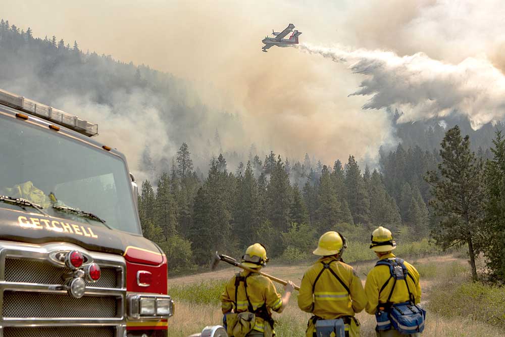
Satellites and sensors are not the only tools in the toolbox of 21st century wildfire fighters. Airplanes and drones help them track and extinguish blazes.
In Idaho, for example, the state Department of Lands contracts for a Fire Boss single-engine air tanker for fire suppression and uses drones for tracking fires. The plane is a cousin of the Air Tractor used by many aerial applicators in agriculture.
The department often deals with smaller fires near communities.
“When you have a four-tenths-acre fire that can burn down two or three homes, it won’t pop up” on satellite imagery, Deputy Chief of Plans Scott Hayes said. IDL often cooperates with local fire departments.
Drones offer a solution to that satellite blind spot.
“The best imagery typically is taken early in the morning. You’re trying to find hot spots, so you want the least amount of ambient temperature,” Hayes said, referring to a drone-mounted infrared camera that “sees” heat.
He “flew” a fire in northern Idaho on May 6, “and it showed a hot spot outside the fire line,” a concern. “We could direct people and resources accordingly.”
Within a few minutes, “that image does you some good on the ground,” Hayes said. Using it in conjunction with a mapping application “gives us the ability to create near-real-time aerial imagery” complete with exact locations.
Drone-based sensors are also important where wildland and urban landscapes intertwine, said Mark Swanson, Washington State University associate professor and forestry program leader.
“What academic institutions need to do is increase educational offerings in drone-based and aircraft-based sensors,” he said.
Tracking the locations of trucks, engines and other equipment also helps fire managers know what resources they have, and where.
Brian Williams is support services manager for the U.S. Bureau of Land Management’s National Fire Equipment Program. He said BLM Location Based Services aims to combine GPS technology with dispatch and suppression programs “to enhance safety, situational awareness and operational efficiency.”
Eighteen types of equipment, from engines, dozers and command vehicles to semi-trucks and crew carriers, comprise the firefighting fleet.
“We currently have 773 satellite terminals installed, and that covers our whole fleet,” Williams said. “Our program is currently focused on tracking the equipment that the firefighters use, and not specifically tracking the individual. In the future, our system could expand into tracking individuals.”
The terminals provide location information viewable on mobile phones and laptop computers. Users can see vehicles and current fire details.
Williams said seeing equipment locations helps managers pre-position resources “and can aid in dispatching the closest resources to a new fire.” Officials hope to integrate the information into dispatching software.
Satellites, drones and planes give wildfire fighters an airborne advantage, but Loren Kellogg knows much of the battle is often fought on the ground.
Enter the Tactical Fire Suppression Forwarder.
The Forwarder combines a state-of-the-art vehicle used in logging with fire suppression equipment and has the potential to work where helicopters once were the only option.
“The system can be used in firefighting or forest treatment,” said Kellogg, an Oregon State University forest engineering professor emeritus. In light of the need for forest restoration and fuel thinning, “in North America in the last 10-15 years, we are starting to see the advantages of this system in our forests.”
Its mountain goat-like abilities to travel across rugged terrain, cut trees and move them out of the way and spray water on hot spots allow it to fight wildfires deep in the backcountry.
“There is not any other equipment now with that ability to get onto steep terrain,” Kellogg said. “These catastrophic wildfires can be just so difficult to contain and control, especially on steep terrain.”
But even with all of the high-tech tools there are still other variables, said Nauslar, the meteorologist. People still have to effectively put those tools to work to control a wildfire, often relying on crews on the ground.
“You can’t model everything, especially when you add the human element,” he said.
