


ONLINE Dan Fulleton Farm Equipment Retirement Auction
THIS WILL BE AN ONLINE AUCTION Visit bakerauction.com for full sale list and information Auction Soft Close: Mon., March 3rd, 2025 @ 12:00pm MT Location: 3550 Fulleton Rd. Vale, OR […]
Published 8:15 am Friday, December 10, 2021
La Nina has apparently arrived in the Northwest, signaling a shift to cooler weather and more promising snowpacks, Washington State Climatologist Nick Bond said Thursday.
November was wet but warm, causing flooding in northwest Washington, but little snow in the Cascade Range. Bond said Thursday he anticipates weather patterns will change, dropping snow in the mountains without raising the risk of floods.
“Things have kind of turned around,” he said. “December looks like a different kind of month than November.
“No guarantee it will stay that way for the entire winter, but at least for the rest of this month, it looks like there will be good mountain snows,” Bond said.
Washington’s statewide snowpack, an average of basins throughout the state, was 53% of normal Friday. The snowpack on the same date in 2014 — the winter of Washington’s “snowpack drought” — was 57%.
“I’m starting to worry, honestly,” said Scott Pattee, water supply specialist for the Natural Resources Conservation Service.
Over the past 30 years, more snow builds up in December than any other month, slightly edging January, according to Washington Department of Ecology calculations.
“If we don’t get good snow in December, we go into the new year in a real deficit,” Pattee said. “We still have a chance to catch up, but we’re falling farther and farther behind everyday.”
In the 2014-15 winter, El Nino conditions prevailed, the opposite of a La Nina. El Nino winters are generally warmer in the northern U.S. As the winter went on that year, Washington’s snowpack fell farther behind normal, leading to a summer shortage for irrigation districts.
“The spigot got turned off at the end of December,” Pattee said.
A La Nina generally leads to cool temperatures in the Northwest. The National Oceanic and Atmospheric Administration said Thursday there’s a 95% chance that La Nina will prevail until the spring.
A La Nina makes the southern U.S. warmer and drier. The La Nina could relieve drought in some parts of the West, but deepen it in other parts. This will be the second La Nina winter in a row.
Bond said the storms that hammered northwest Washington in late November originated farther south than storms expected to be ushered in by La Nina.
The November storms in northwest Washington were “kind of a fluke” and “not a new normal,” but higher global temperatures may not cause such storms to have more moisture in the future, Bond said.
“That is something that is quite possible,” he said. “But it’s not like every year will have floods like this one.”
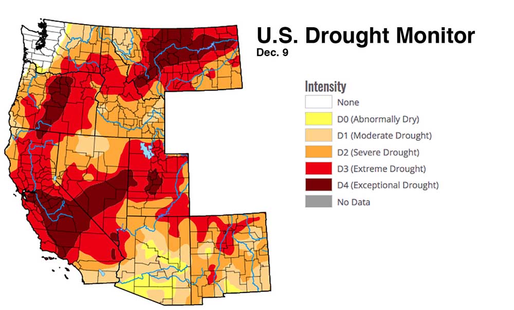
The U.S. Drought Monitor reported Thursday that Western Washington and Clatsop and Tillamook counties in northwest Oregon were the only regions in nine western states that aren’t at least abnormally dry.
Some 94% of the West is in some stage of drought, ranging from moderate to exceptional.
In Eastern Washington, conditions are improving. For the first time since mid-July, no part of the state is in “exceptional drought,” the worst of four classifications.
Most of southeast Washington, making up 16% of the state, remains in “extreme drought,” the second-worst category. Bond said the region must make up a rainfall deficit.
“My suspicion is the drought will be ameliorated, but not eliminated,” he said.
NOAA’s Climate Prediction Center forecasts cool and wet weather in the Northwest for December, January and February.
A swathe of Central Oregon, making up 21% of the state, remains in exceptional drought.
All of Idaho is in drought, including 25% in extreme drought. California also is entirely in drought, including 28% in exceptional drought.

THIS WILL BE AN ONLINE AUCTION Visit bakerauction.com for full sale list and information Auction Soft Close: Mon., March 3rd, 2025 @ 12:00pm MT Location: 3550 Fulleton Rd. Vale, OR […]
Featuring quality surplus farm and dairy equipment from farming operations and dealers across Western, WA. Highlights include sellers from Lynden to Snohomish featuring equipment from Farmers Equipment, Inc., Cleave Farms, […]
Bid Now! Bidding Ends March 12, 10 AM MST Dairy, farm, excavation & heavy equipment, transportation, tools, & more! Register Now! Magic Valley Auction www.MVAidaho.com 208-536-5000
Treasure Valley Livestock Auction Caldwell, Idaho Free Delivery within 400 Miles February 25th, 2025 @ 1PM MST VIEW/BID LIVE ON THE INTERNET: LiveAuctions.TV Find us on Facebook at: Idaho […]
The in-person and virtual conference will feature more than 90 speakers, as well as presentations, panel discussions and networking. Organic Seed Alliance (OSA), along with partner Oregon State University’s Center […]
Live Streaming Auction - February 26, 2025 Timed Auction (Online Only!) - February 27, 2025 View Catalogs: Day 1 | Day 2
Range-Raised • Feedlot-Tested • Carcass-Measured • DNA Evaluated Price Cattle Company with Murdock Cattle Co February 26 Lunch Served At 11:00 AM • Sale Starts 1:00 PM 50 Registered Angus […]
The event features research updates and educational presentations.
Live Streaming Auction - February 26, 2025 Timed Auction (Online Only!) - February 27, 2025 View Catalogs: Day 1 | Day 2
Moving Back Home! In addition to our yearling bulls, we also added some age-advantage bulls. The sale will take place at the Lewiston Roundup Grounds, just South of Lewiston. Both […]
FRIDAY – February 28, 2025 / 8:30 AM 17129 HIGHWAY 99 NE, WOODBURN, OR 97071 AUCTION DETAILS: Auction Begins: Friday – February 28th, 2025 @ 8:30 AM – (PST) Live-online […]
Trinity Farms BETTER BULLS. BRIGHTER FUTURES. Trinity composite bulls, the perfect solution for advanced beef production. 250 Bulls Available Ellensburg, WA • 3.1.2025 www.trinityfarms.info • (509) 201-0775
Preview: Sat. March 1st 9am - 1 pm Biddings Ends: Thurs. March 6th Starting at 6pm Highlights Include: Bulb planter and harvest equipment, disks, plows, harrows, cultipackers, 4 row planter, […]
Heavy Equipment • Tractors • Construction • Farm Equipment • Vehicles • Trucks • Trailers & More! Virtual Online-Only Auction Full Catalog & Bidding Procedures Available at www.yarbro.com Start […]
Booker's Annual Early Spring Eltopia Auction March 6-7, 2025 www.BookerAuction.com | 509.297.9292
2-Day Online Equipment Auction @ Meridian Equipment Auction CO, Bellingham WA. Now Accepting Quality Machinery Consignments AUCTION INFORMATION Online Only Bidding ONLINE BIDDING OPENS: Feb 22, 2025 DAY 1- Online […]
Oregon State University Surplus hosts Annual Farm Sale Bid on 30+ years of local farm surplus! Join OSU Surplus on March 8th at the Lewis Brown Farm in Corvallis for the […]
Join us for the Genetic Edge Bull Sale! 320 Coming Two-Year-Old Bulls • 265 Yearling Bulls • 305 Calving-Ease Bulls Schedule of Events Friday, March 7, 2025 All Day […]
Online Auction - March 12th Bid Now! Dairy, Farm, Excavation & Heavy Equipment, Transportation, Tools, & More! Magic Valley Auction MVAidaho.com 208-536-5000
March Online Equipment Consignment Auction Online Bidding is Wed, March 12th - Wed, March 19th Chehalis Livestock Market 328 Hamilton Rd. N., Chehalis, WA 98532 Follow Us on Facebook! @Chehalis […]
Bidding starts on Wednesday, March 12th Go to www.clmauctions.com and click on Hibid link to view and bid on over 1,000 lots! Lots of great pickups, trailers, tractors, cars, farm trucks, haying […]
ONLINE ONLY AUCTION Schritter Farms Retirement Auction Bidding Now Open! Bids Begin Closing on March 12th @ 9AM MST Multiple Locations - Please See Individual Lots For Their Specific Location, […]
Thursday, March 13th at 9:30 AM Rubber Tired Loaders, Crawler Tractors, Cranes, Motor Graders, Haul Trucks, Excavators, Water Trucks, Truck Tractors, Trailers, Attachments and Support Equipment Carlin (Elko), Nevada HIGHLIGHTS: […]
RAM RIDGE LLC & PALM CONSTRUCTION - ONLINE AUCTION Aggregate Crushing & Heavy Equipment Start Date: 10AM | Thursday - March 13 End Date: 10AM | Thursday - March 20 […]
Thursday, March 13th at 9:30 AM ~ Bill Miller Rentals ~ Rubbered Tired Loaders, Crawler Tractors, Cranes, Motor Graders, Haul Trucks, Excavators, Water Trucks, Truck Tractors, Trailers, Attachments and Support […]
March 14th - March 18th 2025 Changes Farm Operations Maxwell, CA Learn more at AUCTION-IS-ACTION.COM Putnam Auctioneers, Inc. CA Bond No. 7238559 Email: putman.kevin@yahoo.com John Putnam - (530) 710-8596 Kevin […]
Saturday, March 15th 9:30 AM Address: 1800 West Bonanza Rd., Las Vegas, NV 89106 Highlights: 2-Tele. Forklifts: Unused JLG 943, Unused JLG 742, 2-Cab & Chassis: (2)Unused Chevy 5500, 3-Detachable […]
March Online Auction Begins to close @3pm MST | March 17, 2025 Early Listings: *2017 Bobcat 418-A-A Mini Excavator, *International 544 Utility Tractor with Loader, *2016 Bobcat E20 Mini Excavator, […]
Multi-Seller - Open Consignment Bidding Now Open - Additional Items Arriving Daily Starts Closing: Tuesday, March 18th @ 2PM (MT) Tractors • Trucks • Trailers • Construction Equipment • Farm […]
Machinery Auction March 19 & 20 All lots start to close at 8:00 a.m. PST Online Bidding Opens March 14 at 3:00 p.m. PST Items include: Construction Equipment, […]
12:30PM Wednesday, March 19, 2025 Performance Tested Bulls: Angus, Simmental and SimAngus, Red Angus, Charolais 90 Day Breeding Guarantee. Western Breeders Assoc. Bonina Feed and Sale Facility, 430 Ferguson Lane, […]
Booker's Annual Early Spring Offsite Farm Auction Ends March 19, 2025 www.BookerAuction.com | 509.297.9292
MAJOR CONSIGNORS: Twin Falls Highway District; KWS Seeds; Molyneux Family Farms; and Sev'rl Area Farmers throughout the Magic Valley NOTICE: Items listing in this auction are located at multiple locations […]
Saturday, March 22, 2025 • At the Ranch • Sandpoint, ID High maternal easy fleshing Cows Low maintenance Heifers High performance Bulls Selling 47 Bulls and 40 Open Heifers […]
Discover the Estate of Afton Jacobson, offering 743± acres of farmland just 4 miles south of Pullman, WA. This expansive property features 6 parcels, two including residences and outbuildings, providing […]
Live Streaming Auction - March 26, 2025 Timed Auction (Online Only!) - March 27th, 2025 View Catalogs: Day 1 | Day 2
FRIDAY – March 28, 2025 / 8:30 AM 17129 HIGHWAY 99 NE, WOODBURN, OR 97071 AUCTION DETAILS: Auction Begins: Friday – March 28th, 2025 @ 8:30 AM – (PST) Live-online […]
Located: 3021 N 2800 W, Brigham City, Utah 84302. Take Exit 365, go west 1 1/2 mile to 2800 W, turn north 1 1/2 a mile to auction site. Watch […]
© 2025 Capital Press.