


ONLINE Dan Fulleton Farm Equipment Retirement Auction
THIS WILL BE AN ONLINE AUCTION Visit bakerauction.com for full sale list and information Auction Soft Close: Mon., March 3rd, 2025 @ 12:00pm MT Location: 3550 Fulleton Rd. Vale, OR […]
Published 1:23 pm Monday, April 10, 2023
March was colder than normal across Idaho with well above normal precipitation in the southern two-thirds of the state.
Precipitation amounts were so high last month that water supply conversations shifted from “will we get out of drought” to concerns about potential flooding, according to hydrologists with the Natural Resources Conservation Service in Idaho.
In addition to bountiful precipitation, cold weather across the state has delayed the runoff. The delays are especially apparent in the southern Snake River basins, which typically begin runoff season in mid-March.
With April forecast to be cool and wet, increases in streamflow may continue to be delayed, the hydrologists said in their latest Water Supply Outlook Report.
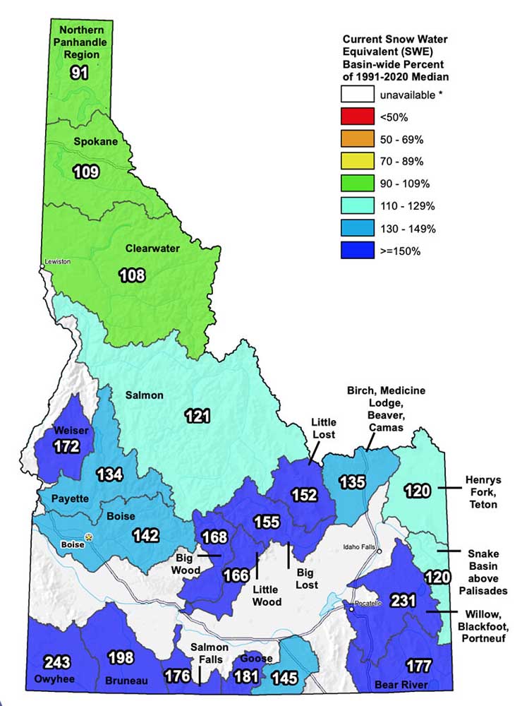
A snowy March set records at many SNOTEL remote telemetry stations and snow courses, and the snowpack is near to well above normal across the entire state.
Basins south of the Clearwater River, which includes Lewiston, have the highest snowpack percentages. Although March wasn’t quite as wet in northern Idaho, all basins in that area have reached normal snowpack conditions. Only the northern Panhandle region near Canada has less than 100% of normal snow water equivalent. It is at 91%.
Snowpack ranges from 113% to 226% in the rest of the state as of April 1. Compared to median snowpack values in each basin, snowpack ranges from 84% to 168%.
“Whatever metric you use, we can agree this has been a banner snow year for southern Idaho that will be talked about for years to come,” the hydrologists said.
Water supply looks more than adequate across the state given the robust snowpack. But due to low reservoir storage in the Upper Snake River system, water supply could still be limited for some water users despite the improvements in this month’s streamflow forecasts.
Water users in all basins, apart from the Upper Snake River, can expect sufficient water supply this irrigation season, they said.
“This holds true especially if we have normal to above normal spring precipitation,” they said.
While water supply may still be limited for some water users in the Upper Snake River, the water supply picture for the region has vastly improved over the winter.
April 1 streamflow forecast volumes increased significantly from last month, reflecting the well above normal March precipitation and massive gains in the snowpack.
“The unusually large amounts of snow still lingering at the low and mid-elevations strongly influenced the rise in snowmelt runoff forecasts,” they said.
Reservoir storage is still below normal across many parts of the state because inflow into reservoirs has been low this winter. Streamflow for Oct. 1 to April 1 is well below normal, reflecting the multi-year drought, reduced groundwater and dry soil conditions as well as the colder than normal temperatures.
“However, once the snowpack begins melting, we will quickly see reservoirs begin to fill,” they said.
As of March 9, reservoir storage was 56% of capacity in the Upper Snake River system, 62% of capacity in the Boise River system and 61% of capacity in the Payette River system, according to the Bureau of Reclamation.
Streamflow, snowpack and precipitation data for each basin can be accessed at https://bit.ly/3UmTp3A .
