


ONLINE Dan Fulleton Farm Equipment Retirement Auction
THIS WILL BE AN ONLINE AUCTION Visit bakerauction.com for full sale list and information Auction Soft Close: Mon., March 3rd, 2025 @ 12:00pm MT Location: 3550 Fulleton Rd. Vale, OR […]
Published 1:00 pm Wednesday, July 10, 2024
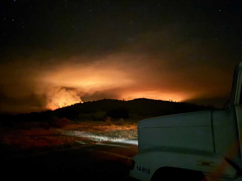
The Salt Creek Fire burning 10 miles east of Eagle Point grew by about 300 acres in the last 24 hours to over 3,650 acres, and fire crews have the blaze about 7% contained, according to a Wednesday morning update from Oregon Department of Forestry Incident Management Team 1.
Roughly 80% of the fire has been lined, according to the update, which is posted to the fire’s official Facebook page.
Five hundred and fifty-five personnel are working the fire on Wednesday’s day shift, the update said. Resources include “20 20-person crews, 21 engines, 12 bulldozers, 13 water tenders,” the update said. “A Rogue Valley Task Force made up of local resources is also available if needed.”
Firefighters will once again toil amid wind and high heat, with temperatures expected to climb over 100 degrees, conditions likely to increase fire activity, the update said.
“That’s some pretty extreme heat to be fighting fire in,” Kyle Gibbons, ODF IMT 1’s operations section chief, said in a video posted to the Salt Creek Fire 2024 Facebook page.
The southeast corner, which Gibbons called the “problem area of the fire at the moment,” will be firefighters’ focus for Wednesday as crews work to establish both direct and indirect lines, he said in the video.
His team doesn’t have the fire “totally wrapped up yet, but making progress every day,” Gibbons said.
The fire broke out shortly after 4 p.m. Sunday, and its cause is under investigation. As of Wednesday, the fire’s estimated cost is $1.6 million.
ODF IMT1 took command of the fire on Monday to allow ODF Southwest Oregon District crews to focus on new fire starts, according to an earlier release from the agency.
Jackson County Sheriff’s Office and Jackson County Emergency Management have issued an “Evacuation Level 1: ‘Be ready'” notice for Zones JAC-316, JAC-317, JAC-319 and JAC-321, ODF said Sunday.
The zones are north of Highway 140, approximately 12 miles east of Eagle Point in the Lake Creek area, east of Salt Creek Road, south and west of Fish Lake Road, including the Willow Lake area, the post said.
On Tuesday, Jackson County Emergency Management added evacuation zone JAC-325-A, largely located southwest of Esmond Mountain and bordering on the south at Highway 140.
Structural firefighters are on hand to protect homes in these zones, the Wednesday morning update said.
More info on evacuation zones can be found at Genasys Protect.
Salt Creek Road and Wasson Canyon Road are closed at Highway 140, ODF said, and Double Day Road is closed off at Butte Falls Highway. Highway 140 and Butte Falls Highway remain open, but officials urge residents to stay clear of crews working in the fire zone.
The fire danger level in the Southwest Oregon District switched over to “extreme” (red) on Tuesday.
The Shelly Fire in the Klamath National Forest in Northern California was listed at 8,285 acres Wednesday and is 0% contained, according to the Inciweb website.
This is a developing story.

THIS WILL BE AN ONLINE AUCTION Visit bakerauction.com for full sale list and information Auction Soft Close: Mon., March 3rd, 2025 @ 12:00pm MT Location: 3550 Fulleton Rd. Vale, OR […]
Featuring quality surplus farm and dairy equipment from farming operations and dealers across Western, WA. Highlights include sellers from Lynden to Snohomish featuring equipment from Farmers Equipment, Inc., Cleave Farms, […]
Bid Now! Bidding Ends March 12, 10 AM MST Dairy, farm, excavation & heavy equipment, transportation, tools, & more! Register Now! Magic Valley Auction www.MVAidaho.com 208-536-5000
Treasure Valley Livestock Auction Caldwell, Idaho Free Delivery within 400 Miles February 25th, 2025 @ 1PM MST VIEW/BID LIVE ON THE INTERNET: LiveAuctions.TV Find us on Facebook at: Idaho […]
The in-person and virtual conference will feature more than 90 speakers, as well as presentations, panel discussions and networking. Organic Seed Alliance (OSA), along with partner Oregon State University’s Center […]
Live Streaming Auction - February 26, 2025 Timed Auction (Online Only!) - February 27, 2025 View Catalogs: Day 1 | Day 2
Range-Raised • Feedlot-Tested • Carcass-Measured • DNA Evaluated Price Cattle Company with Murdock Cattle Co February 26 Lunch Served At 11:00 AM • Sale Starts 1:00 PM 50 Registered Angus […]
The event features research updates and educational presentations.
Live Streaming Auction - February 26, 2025 Timed Auction (Online Only!) - February 27, 2025 View Catalogs: Day 1 | Day 2
Moving Back Home! In addition to our yearling bulls, we also added some age-advantage bulls. The sale will take place at the Lewiston Roundup Grounds, just South of Lewiston. Both […]
FRIDAY – February 28, 2025 / 8:30 AM 17129 HIGHWAY 99 NE, WOODBURN, OR 97071 AUCTION DETAILS: Auction Begins: Friday – February 28th, 2025 @ 8:30 AM – (PST) Live-online […]
Trinity Farms BETTER BULLS. BRIGHTER FUTURES. Trinity composite bulls, the perfect solution for advanced beef production. 250 Bulls Available Ellensburg, WA • 3.1.2025 www.trinityfarms.info • (509) 201-0775
Preview: Sat. March 1st 9am - 1 pm Biddings Ends: Thurs. March 6th Starting at 6pm Highlights Include: Bulb planter and harvest equipment, disks, plows, harrows, cultipackers, 4 row planter, […]
Heavy Equipment • Tractors • Construction • Farm Equipment • Vehicles • Trucks • Trailers & More! Virtual Online-Only Auction Full Catalog & Bidding Procedures Available at www.yarbro.com Start […]
Booker's Annual Early Spring Eltopia Auction March 6-7, 2025 www.BookerAuction.com | 509.297.9292
2-Day Online Equipment Auction @ Meridian Equipment Auction CO, Bellingham WA. Now Accepting Quality Machinery Consignments AUCTION INFORMATION Online Only Bidding ONLINE BIDDING OPENS: Feb 22, 2025 DAY 1- Online […]
Oregon State University Surplus hosts Annual Farm Sale Bid on 30+ years of local farm surplus! Join OSU Surplus on March 8th at the Lewis Brown Farm in Corvallis for the […]
Join us for the Genetic Edge Bull Sale! 320 Coming Two-Year-Old Bulls • 265 Yearling Bulls • 305 Calving-Ease Bulls Schedule of Events Friday, March 7, 2025 All Day […]
Online Auction - March 12th Bid Now! Dairy, Farm, Excavation & Heavy Equipment, Transportation, Tools, & More! Magic Valley Auction MVAidaho.com 208-536-5000
March Online Equipment Consignment Auction Online Bidding is Wed, March 12th - Wed, March 19th Chehalis Livestock Market 328 Hamilton Rd. N., Chehalis, WA 98532 Follow Us on Facebook! @Chehalis […]
ONLINE ONLY AUCTION Schritter Farms Retirement Auction Bidding Now Open! Bids Begin Closing on March 12th @ 9AM MST Multiple Locations - Please See Individual Lots For Their Specific Location, […]
Thursday, March 13th at 9:30 AM Rubber Tired Loaders, Crawler Tractors, Cranes, Motor Graders, Haul Trucks, Excavators, Water Trucks, Truck Tractors, Trailers, Attachments and Support Equipment Carlin (Elko), Nevada HIGHLIGHTS: […]
RAM RIDGE LLC & PALM CONSTRUCTION - ONLINE AUCTION Aggregate Crushing & Heavy Equipment Start Date: 10AM | Thursday - March 13 End Date: 10AM | Thursday - March 20 […]
Thursday, March 13th at 9:30 AM ~ Bill Miller Rentals ~ Rubbered Tired Loaders, Crawler Tractors, Cranes, Motor Graders, Haul Trucks, Excavators, Water Trucks, Truck Tractors, Trailers, Attachments and Support […]
March 14th - March 18th 2025 Changes Farm Operations Maxwell, CA Learn more at AUCTION-IS-ACTION.COM Putnam Auctioneers, Inc. CA Bond No. 7238559 Email: putman.kevin@yahoo.com John Putnam - (530) 710-8596 Kevin […]
Saturday, March 15th 9:30 AM Address: 1800 West Bonanza Rd., Las Vegas, NV 89106 Highlights: 2-Tele. Forklifts: Unused JLG 943, Unused JLG 742, 2-Cab & Chassis: (2)Unused Chevy 5500, 3-Detachable […]
March Online Auction Begins to close @3pm MST | March 17, 2025 Early Listings: *2017 Bobcat 418-A-A Mini Excavator, *International 544 Utility Tractor with Loader, *2016 Bobcat E20 Mini Excavator, […]
Multi-Seller - Open Consignment Bidding Now Open - Additional Items Arriving Daily Starts Closing: Tuesday, March 18th @ 2PM (MT) Tractors • Trucks • Trailers • Construction Equipment • Farm […]
Machinery Auction March 19-21 All lots start to close at 8:00 a.m. PST Online Bidding Opens March 14 at 3:00 p.m. PST Items include: Construction Equipment, ATVs, Farm […]
12:30PM Wednesday, March 19, 2025 Performance Tested Bulls: Angus, Simmental and SimAngus, Red Angus, Charolais 90 Day Breeding Guarantee. Western Breeders Assoc. Bonina Feed and Sale Facility, 430 Ferguson Lane, […]
Booker's Annual Early Spring Offsite Farm Auction Ends March 19, 2025 www.BookerAuction.com | 509.297.9292
MAJOR CONSIGNORS: Twin Falls Highway District; KWS Seeds; Molyneux Family Farms; and Sev'rl Area Farmers throughout the Magic Valley NOTICE: Items listing in this auction are located at multiple locations […]
Saturday, March 22, 2025 • At the Ranch • Sandpoint, ID High maternal easy fleshing Cows Low maintenance Heifers High performance Bulls Selling 47 Bulls and 40 Open Heifers […]
Live Streaming Auction - March 26, 2025 Timed Auction (Online Only!) - March 27th, 2025 View Catalogs: Day 1 | Day 2
FRIDAY – March 28, 2025 / 8:30 AM 17129 HIGHWAY 99 NE, WOODBURN, OR 97071 AUCTION DETAILS: Auction Begins: Friday – March 28th, 2025 @ 8:30 AM – (PST) Live-online […]