


ONLINE Dan Fulleton Farm Equipment Retirement Auction
THIS WILL BE AN ONLINE AUCTION Visit bakerauction.com for full sale list and information Auction Soft Close: Mon., March 3rd, 2025 @ 12:00pm MT Location: 3550 Fulleton Rd. Vale, OR […]
Published 2:00 pm Tuesday, July 16, 2024
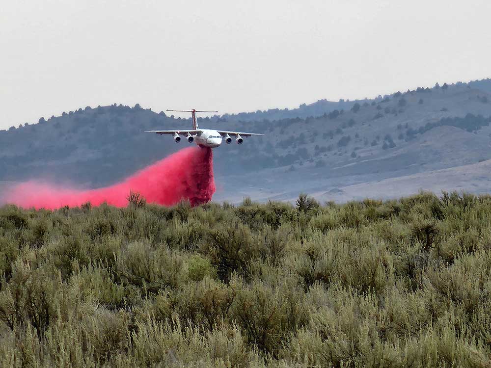
Crews battling the 133,000-plus-acre Cow Valley Fire in southeastern Oregon found success — and some weather-related good luck — July 15.
“Every day on a fire is important when you are in suppression phase,” Jessica Reed, a public information officer with Northwest Team 6, said of the Cow Valley Fire early July 16. The team is managing the fire.
“Yesterday, we had slightly cooler temperatures, and firefighters were able to take advantage of that with their suppression tactics,” she said. “Today, they are working to connect fire lines.”
In the slightly higher temperatures of July 16, Cow Valley “continues to be active” in the southwest area, where firefighters are working to connect lines, Reed said.
The fire is 20% contained, and the containment is in the northern section, she said. “We have crews working there to extinguish hot spots.”
The Cow Valley Fire’s containment is based on a high probability that the fire will not move across lines under predicted weather conditions, according to a July 16 update circulated by the U.S. Bureau of Land Management, the Oregon State Fire Marshal and Team 6.
Fire growth was minimal July 15, and the 133,408-acre fire’s eastern and southern edges continued to hold as of early July 16, according to the update. The human-caused fire, nine miles east of Ironside, remains under investigation. Containment increased to 20% early July 17.
About 10 miles southeast of Condon, the Lone Rock Fire started July 13 and grew to more than 30,000 acres in gusty winds and dry conditions, according to a July 16 news release from the state fire marshal’s office. Acreage increased to 71,000, containment to 10%, as of early July 17.
The office’s Red Incident Management Team is working with Northwest Team 2 and structural task forces from Benton, Clackamas, Lane, Linn, Marion, Multnomah and Yamhill counties. The Linn County task force and other resources were sent July 14.
Gilliam County and Wheeler County fire departments as well as Heppner, Irrigon, Boardman and Irrigon fire departments in Morrow County and Echo Fire Department from Umatilla County have also been dispatched on the fire.
Sheriff’s offices in Gilliam, Morrow and Wheeler counties enacted levels 2 and 3 evacuations.
Because the threat to homes near the Cow Valley Fire has diminished, the state fire marshal’s office was able to demobilize and reassign its red team and several of the task forces.
“The next few days are going to be extremely challenging with excessive heat, red flag warnings, and forecasted lightning,” Mariana Ruiz-Temple, state fire marshal, said in the release. “We are watching the weather forecast closely and have plans in place if new fires start.”
Meanwhile, firefighters remain hard at work elsewhere in Oregon, Washington, Idaho and California as U.S. burned acreage stays well ahead of last year.
The Boise-based National Interagency Fire Center and the Inciweb Incident Information System track large wildfires — typically those that are at least 100 acres in timber or 300 on rangeland, involve an incident management team or are multi-fire complexes.
NIFC on July 16 reported that 59 large, active wildfires that have burned 933,583 acres combined were being managed around the country. Some 39 involve full suppression strategies.
U.S. acres burned from Jan. 1-July 16 approach 3.09 million, up fourfold from 770,291 a year earlier, according to NIFC.
The U.S. Forest Service on July 16 activated four specially equipped U.S. Department of Defense C-130 cargo aircraft to assist with increased wildfire activity across the West. The planes — initially working out of Channel Islands Air National Guard Station in California — are based in California, Colorado, Nevada and Wyoming. The planes are equipped with Modular Airborne Firefighting Systems that can drop up to 3,000 gallons of retardant in less than 10 seconds across a quarter mile line, according to a Fire Center news release.
Selected active Western wildfires as of July 16 (Source: NIFC unless noted otherwise)
Bonita Road, nine miles southeast of Ironside, 2,727 acres, 80% contained.
Cow Valley, nine miles east of Ironside, 133,408 acres, 20% contained early July 17. (Northwest Team 6)
Falls, five miles southwest of Butte Falls, 64,225 acres, no containment.
Salt Creek, five miles southwest of Butte Falls, 4,102 acres, 73% contained.
Larch Creek, 15 miles south of The Dalles, 18,684 acres, 14% contained.
Lone Rock, 10 miles southeast of Condon, 71,000 acres, 10% contained early July 17.
Upper Pine, 23 miles northeast of Burns, 1,086 acres, 85% contained.
Basin, 28 miles northeast of Sanger, 14,023 acres, 95% contained.
Cow 2, 13 miles east of Porterville, 509 acres, 80% contained
Hurricane, 19 miles northwest of Maricopa, 12,703 acres, 80% contained.
Lake, nine miles northeast of Los Olivos, 38,430 acres, 38% contained.
Packsaddle, 12 miles north of Kernville, 46 acres, no containment.
Trout, 18 miles north of Kernville, 2,095 acres, no containment.
Rancho, 28 miles southeast of Bakersfield, 9,950 acres, 65% contained.
Rim, 21 miles northeast of Old Station, 1,025 acres, 20% contained.
Sheering, 15 miles northeast of Tuolumne, 528 acres, 96% contained.
Shelly, eight miles west of Etna, 14,309 acres, 6% contained.
Vista, five miles southeast of Wrightwood, 2,936 acres, 59% contained.
White, 12 miles south of Tehachapi, 5,536 acres, 23% contained.
Lost Hills, Kern County, 2,818 acres, no containment (California Department of Forestry and Fire Protection / Cal Fire).
Cow, Tulare County, 509 acres, 80% contained (Cal Fire).
Five (5), Kern County, 348 acres, no containment (Cal Fire).
Point, Modoc County, 298 acres, 58% contained (Cal Fire).
Royal, Placer County, 215 acres, 95% contained. (Cal Fire).
Less than 200 acres: Soda in San Luis Obispo County, Dewey and Paradise in Siskiyou County, Laura in Kern County and Mina in Mendocino County (Cal Fire).
Bench Lake, eight miles south of Stanley, 677 acres, no containment.
Texas, east of Kendrick, 1,200 acres, no containment (Idaho Department of Lands).
Pioneer, 31 miles northwest of Chelan, 18,731 acres, 14% contained.
Shoofly, 16 miles northeast of Skyhomish, 104 acres, 56% contained.
