


ONLINE Dan Fulleton Farm Equipment Retirement Auction
THIS WILL BE AN ONLINE AUCTION Visit bakerauction.com for full sale list and information Auction Soft Close: Mon., March 3rd, 2025 @ 12:00pm MT Location: 3550 Fulleton Rd. Vale, OR […]
Published 9:15 am Tuesday, October 1, 2024
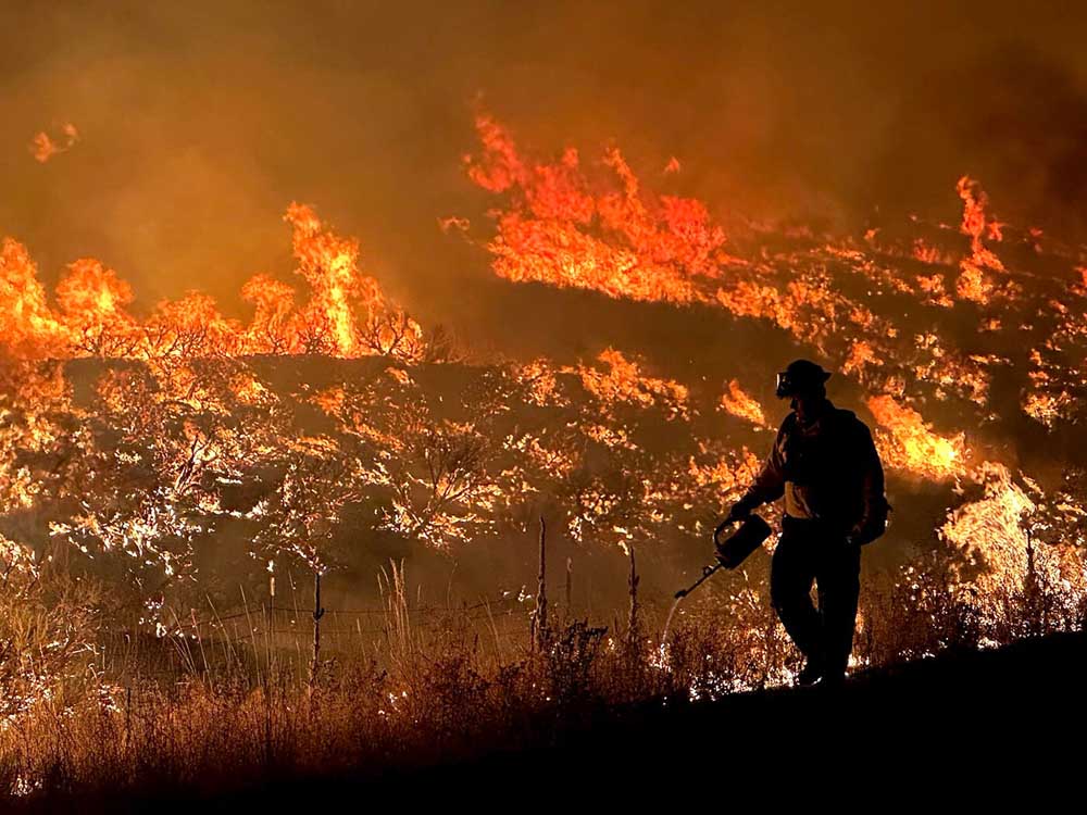
JOHN DAY, Ore. — It’s been a long, hot summer in Grant County.
In July, a wave of wildfires erupted in seemingly every corner of the county, prompting a flurry of evacuation notices.
In September, just as those fires were being brought under control, lightning sparked yet another series of blazes, some of which coalesced into one big burn that forced still more evacuations and is threatening to match the earlier acreage total all by itself.
Now comes the reckoning.
While damage reports are still coming in, the preliminary numbers are staggering.
As of the most recent tally, a total of 314,172 acres has burned in Grant County this summer, according to estimates put together by Eric Bush, the county’s emergency management coordinator, and Kyle Sullivan of the Grant Soil and Water Conservation District. That’s just over 490 square miles — or nearly 11% of the county’s total area.
Most of the acreage burned was public land, but more than a third — 87,882 acres — was private ground. Bush and Sullivan believe about 155 landowners suffered some level of damage to their property.
A total of 16 structures, including two primary residences, were lost to the flames. Miles upon miles of fencelines were destroyed, and an as-yet-unknown number of livestock were killed.
The most serious loss, of course, was the death of an air tanker pilot killed in a crash near Seneca. James Bailey Maxwell, 74, of Clarkston, Washington, was working under contract with the Bureau of Land Management when his single-engine aircraft went down shortly before 7 p.m. on July 25.
While fire season isn’t over yet, it’s already been a historically destructive year for Oregon, with nearly 2 million acres burned, state officials told lawmakers Sept. 24.
Driven by unusually hot and dry conditions, wildfires flared across a huge swath of Eastern Oregon in mid-July. By the end of the month, six major blazes were burning in Grant County or nibbling at its edges.
Burning partly or entirely within the county was the Falls Fire, which eventually consumed 152,000 acres, as well as the 20,000-acre Courtrock Fire and the 183,000-acre Battle Mountain Complex. Just over the county line were the 54,000-acre Telephone Fire, the 87,000-acre Crazy Creek Fire and the 137,000-acre Lone Rock Fire.
While all of those fires were fully contained, or nearly so, by the end of August, a second wave of wildfires struck Grant County on Labor Day, Sept. 2, when a storm front rolled through the region, leaving numerous lightning-sparked fires in its wake.
Most of the fires were small and quickly contained, but several blazes in the South Fork John Day River drainage south of Dayville merged to form the Rail Ridge Fire.
And Rail Ridge was a beast.
Initially reported at 70 acres on Sept. 2, it blew up to more than 61,000 acres in its first 24 hours, burning 7 miles south of Dayville, a town of 142 people.
Four days later, on Sept. 6, it surged past the 100,000-acre mark to become a full-fledged megafire.
Four days after that, on Sept. 10, the fire was within half a mile of Dayville, and backfires had to be set to save the town.
As of this writing, the fire had grown to 165,000 acres. The vast majority of that acreage was in Grant County, with smaller amounts in Crook and Wheeler.
Containment of the blaze had grown as well, however, reaching 74%, and the most urgent evacuation notices — Level 3 — had been dialed back to Level 1 or 2.
So far, there is no reliable estimate of the total financial losses inflicted on Grant County residents by the fires.
“We’re still going through the data,” Bush said.
While some of the homes, cabins and outbuildings destroyed by the flames come with well-established valuations, other structures do not — such as the 140-year-old log corral that burned in the Murderers Creek drainage.
“It’s really hard to put a value on that,” Bush said. “From a historical standpoint, we’ve lost some things.”
Other kinds of losses come with costs, as well.
Livestock producers whose private pastures or public grazing allotments burned are being forced to buy feed for their cattle. They will also need to replace damaged fences — not only on their own ranches but also, in some cases, on their grazing allotments on federal land.
“Ranchers have been through this before with their Forest Service allotments,” Bush said.
“There are programs for replacing those fences, but it can take a year or two to get a contractor out there to fix it, and a lot of times it makes more sense for ranchers to go out and do it themselves.”
In the meantime, the Grant Soil and Water Conservation District is working to secure government relief funding by gathering information on damage to fences, developed springs, structures, equipment, timber, roads, rangeland and feed.
“There is some good news,” Sullivan said. “The (Natural Resource Conservation Service) has released $2 million for the landowners affected.”
Only five Grant County landowners were among the beneficiaries of that first round of relief funding, Sullivan said, but more assistance may be coming.
He’s encouraging landowners to contact the Farm Service Agency at 541-575-1274 to see what programs they may qualify for. He’s also asking them to fill out a form detailing their losses at grantswcd.net/2024_wildfire_impacts — information that could help unlock additional government funding for fire recovery.
“We’re trying to get this information consolidated,” Sullivan said, “so we can understand the impact.”
