


ONLINE Dan Fulleton Farm Equipment Retirement Auction
THIS WILL BE AN ONLINE AUCTION Visit bakerauction.com for full sale list and information Auction Soft Close: Mon., March 3rd, 2025 @ 12:00pm MT Location: 3550 Fulleton Rd. Vale, OR […]
Published 8:30 am Monday, June 17, 2024
When it comes to putting out wildfires in the Pacific Northwest, collaboration is key and agencies are increasingly dependent on each other for resources and information.
This is especially evident in Central Oregon as the U.S. Forest Service, the Bureau of Land Management, the Oregon Department of Forestry and local law enforcement coordinate to protect Bend, Sisters, La Pine and other communities from wildfire.
During summer this means dispatching aircraft and wildland firefighters into fire zones.
The sheriff’s office may get involved if an evacuation order is needed.
Health and environment officials are also on hand to help monitor smoke levels. All agencies actively coordinate their public messaging with information on wildfire locations, threat levels and air pollution risk.
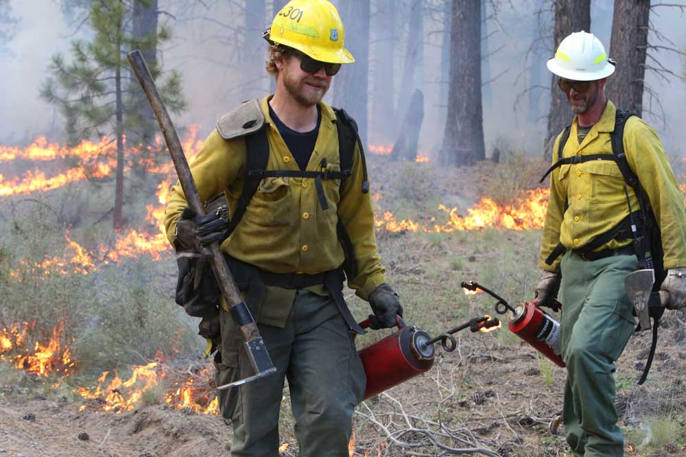
The public sees some of their work firsthand when aircraft fly over the Cascades to drop water or deliver smoke jumpers to a fire.
Hotshot crews can be seen trucking their way to fire events.
But what happens behind the scenes is often where the fight against a wildfire is lost or won.
How do the agencies coordinate their wildfire suppression efforts?Fire managers monitor the location of fires and keep track of lightning strikes using satellite imagery and infrared technology. A dispatch center in Redmond coordinates with Deschutes County 911 during the dispatching phase to share information about incidents and resources responding.
Coordination begins to take shape if a fire grows and requires multiple agencies. These agencies work together based on the closest resource. Sometimes it may be a unified command operation and other times management is under one agency. Even if it is not a unified command, mutual aid agreements allow resources from multiple agencies to respond and support incident operations.
Establishment of command is usually based on location. If the fire is located inside Bend city limits, Bend Fire will most likely be in command.
Then, if the fire threatens federal, state or private land outside city limits, the Oregon Department of Forestry and other organizations may get involved in providing assistance. Command starts with whoever is first on scene and then may transfer to a qualified person usually with the agency that has primary jurisdiction.
Every wildfire is different and actions taken vary based on the specific situation. First, an assessment is made and information is gathered on what kind of vegetation is burning, how quickly the fire is spreading, and what kind of resources are needed to suppress the fire. Officials also review what is at risk from the fire, people infrastructure, buildings, homes and people. Right away agencies try to provide protection to structures and life.
Setting up the organizational structure is among the first steps.
“Once you get into extended attack, more than two hours, you get into incident command, so you’d designate an incident commander and based on the complexity of fire you’d designate staff,” explains Deschutes County Forester Kevin Moriarty.
As a fire grows, incident commanders determine how many resources they need for that fire. A helicopter or plane (but few other resources) may be required if the fire is in a remote wilderness location.
Fires located in an urban setting or the wildland urban interface require more resources to protect assets, such as structures, buildings, infrastructure (i.e. campground outhouses), historic landmarks or fences.
Moriarty says the concentration of population makes the difference. When fire approaches a neighborhood with homes on small-sized lots an evacuation order may be set. With that comes fire engines and hose hook-ups to hydrants.
“In a rural area you may only have to worry about one structure or one house,” said Moriarty. “And you are looking more at treating wildland fuels, using more hand crews, and using chainsaws, and cutting out areas and potentially burning out areas, essentially using fire to stop fire.”
In summer, field stations are set up for rapid response. In rural areas, fuel mitigation work is conducted in between fires, especially around campsites and other public areas.
At the local level, Central Oregon’s 13 Fire Protection Districts (e.g. Sisters, Bend, La Pine, Cloverdale, and Bend rural) are funded by local taxes and levies.
One rung up, state spending comes mainly from the Oregon Department of Forestry’s wildfire protection budget, which last year stood at $104 million. For this fiscal year, the budget is $113 million. This funding does not include large fire costs, said Joy Krawczyk, public affairs office for the Oregon Department of Forestry. Last year, large fire costs increased Oregon Department of Forestry spending by an additional $75.6 million.
Funds used by the U.S. Forest Service and the Bureau of Land Management are raised at the federal level. Congress allocates money specifically for wildfire preparedness. In 2021, the United States spent a record $4.4 billion to fight wildfires, according to the National Interagency Fire Center. Spending dropped to $3.5 billion in 2022 and $3.2 billion a year ago.
The reasons vary based on the location of the fire and the resources available. A fire near the wildland urban interface will receive more resources than one in a remote area because the priority is saving lives and property. The availability of resources also comes into play as summer progresses. As wildfire season heats up, resources are spread thin across the country and priorities go to fires threatening communities.
Each wildfire is assigned a category depending on its size and complexity. Fires assigned with a Type 4 or Type 5 designation are small and require a few resources to stop the fire’s spread within one or two work shifts, according to Jaimie Olle, a spokesperson for the Deschutes National Forest.
Olle says a Type 3 incident is larger than Type 4 or 5 and/or has additional complexities, possibly due to the location or proximity to people or property. Firefighters usually spend multiple days working on a Type 3 fire and may require additional resources.
Type 2 or Type 1 fires are considered complex incidents and require a large number of resources, many of which are from outside the area.
Moriarty says Type 1 fires generally have a higher level of complexity due to what is at risk but are not necessarily bigger in size; Type 1 typically requires the command team to take on more logistics. These teams are pre-organized in the region and can be deployed to any incident in the Northwest within 48 hours.
Planes with retardant are deployed to slow the fire down to buy time for firefighters to reach the area and conduct suppression tactics. These planes are most effective in rangelands or areas with little to no tree canopy. Helicopters that can drop water are effective in areas with high tree canopy. They are likewise used to cool off a fire, supporting firefighters on the ground.
Fire is sometimes allowed to burn in remote wilderness areas if it doesn’t present a threat to lives or property. Officials have predetermined which areas can burn without intervention. But even in remote locations, officials might block a fire from going in one direction or another based on what is nearby. Fire can therefore be manipulated or funneled toward fire breaks.
Allowing a fire to burn is only permitted when a fire is caused by a lightning strike. Human-caused fires must be controlled and put down.
City Club: How wildfire decisions are made
Continuing the conversation: How Wildfire Decisions are Made in Partnership with The Bulletin
Speakers:
Kevin Moriarty, Deschutes County Forester
Shawn Jaca, Central Oregon Fire Management,
US Forest Service
Trey Leonard, Confederated Tribes of Warm Springs
James Osborne, BLM Fire Management Officer,
Prineville District Bureau of Land Management
and Central Oregon Fire Management Service
Moderated by: Jessica Neujahr,
Oregon Department of Forestry
When: 11:30 a.m. to 1 p.m.
Where: Unitarian Universalist Fellowship of Central Oregon
To register go to cityclubco.org
Interagency Partners
Central Oregon Interagency Dispatch Center Partners include:
Oregon Department of Forestry (Prineville and Sisters units): These units protect approximately 450,000 acres of privately owned forestland in Crook, Deschutes, and Jefferson counties.
Bureau of Land Management: The Prineville District consists of over 1.65 million acres of public lands.
U.S. Forest Service: Deschutes and Ochoco National Forests, and the Crooked River National Grassland. These areas encompass over 2.5 million acres of Central Oregon.
Wildfire Resources
Central Oregon Fire Info (centraloregonfireinfo.org) contains up-to-date information on wildfires and prescribed burns occurring around the region.
For active wildfires, visit the website InciWeb (inciweb.wildfire.gov) an interagency website.
