


ONLINE Dan Fulleton Farm Equipment Retirement Auction
THIS WILL BE AN ONLINE AUCTION Visit bakerauction.com for full sale list and information Auction Soft Close: Mon., March 3rd, 2025 @ 12:00pm MT Location: 3550 Fulleton Rd. Vale, OR […]
Published 9:30 am Friday, June 28, 2024
Al Crouch, like his fellow wildfire managers in Eastern Oregon, wondered what June would bring.
July, as it turned out.
In the final days of a June that was both warmer and drier than average across the region, the wildfire danger has increased substantially.
“We’re seeing July in June, and that’s a huge indicator for us,” said Crouch, fire mitigation specialist for the Bureau of Land Management’s Vale District, on June 25.
“The grass load in many areas is very high, and the fuels are drying out very rapidly,” Crouch said.
And flames are spreading fast when they get started, he said.
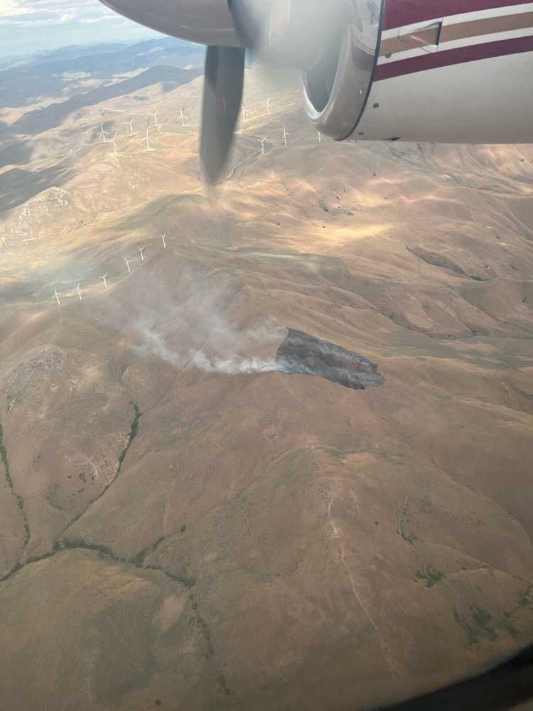
A blaze near Harper, west of Vale, burned 20 acres on the afternoon of June 24.
Crouch said the fire likely would have scorched a much larger area if not for a quick response from multiple agencies.
“Fires are burning very well for this time of year,” he said.
A fire west of Vale burned 18,000 acres of rangeland in several hours on June 26, fueled by temperatures in the 90s and gusty winds.
Crouch and his counterparts from other agencies, including the U.S. Forest Service and Oregon Department of Forestry, said in early June the next month or so would greatly affect how quickly the fire risk escalated.
“June’s kind of a catalyst,” said Joel McCraw, assistant fire management officer for the Wallowa-Whitman National Forest.
And instead of delaying the onset of the fire season, the month accelerated it.
“It’s dry out there,” McCraw said on June 26.
April and May were generally wetter than usual in much of the region.
At the Eastern Oregon Regional Airport in Pendleton, rainfall during May totaled 2.62 inches, more than double the long-term average of 1.21 inches.
Rainfall was closer to average at the Baker City Airport, with 1.55 inches compared with an average of 1.43.
“We had a wet, cold spring, and we’re still catching up from that,” McCraw said.
But the spigot in the sky largely shut off starting June 1.
As of June 26, rainfall for the month was below average across Northeastern Oregon.
Baker County was especially dry, with a monthly total at the Baker City Airport of just 0.10 of an inch, compared with an average of almost 1 inch.
The La Grande-Union County Airport recorded 0.79 of an inch from June 1-26 — the average for the period is 1.14 inches.
The situation was similar at the Eastern Oregon Regional Airport in Pendleton (0.51 of an inch; average of 0.98) and at Hermiston (0.26 of an inch; average of 0.57).
“It’s uncharacteristically dry for the third week of June,” said Matt Howard, district forester for the Oregon Department of Forestry’s Northeast Oregon District.
The lack of moisture, combined with high temperatures and frequently gusty wind, has cured much of the grass that was nourished by the ample rain earlier in the spring.
The average daily high at the Baker City Airport was running more than 4 degrees above normal as of June 26.
The Pendleton Airport was about 1.5 degrees above normal.
Crouch said that although hot weather is hardly unusual in June, he and other fire officials have noticed more wind than is typical.
“People might not realize how much wind helps dry things out, as well as spreading fires,” he said.
The wind was spawned by a series of cold fronts that moved through the region (meteorologists sometimes call these features “cool” fronts during summer because they usher in air that’s relatively cooler but still warm, and in some cases still above average).
The Oregon Department of Forestry declared the official start of fire season in the region on June 22. That means burning permits are required, and other restrictions are in place, for about 2 million acres of private and state land in Northeastern Oregon.
The agency has also increased the fire danger rating on lands it protects from low to moderate.
Howard, the agency’s district forester, said on June 25 that based on conditions at the start of the month, he anticipated fire season might not start until late June or early July.
But the summer-like weather that dominated the month changed the situation.
“Our grass fuels are curing and the dead and down fuels in the forest are below average in moisture,” Howard said. “The fires we have been having have been moving a bit.”
Neither the Forest Service nor the BLM has imposed seasonal restrictions on campfires, firewood cutting or other activities on public land.
But Crouch said he expects the BLM’s Vale District will enact restrictions relatively soon.
He said the conditions that have elevated the fire danger in the southern part of the district, including Malheur County and roughly the southern half of Baker County, are spreading to higher elevations and to the north.
McCraw said Forest Service officials will also be tracking fire indexes and weather forecasts as they decide when public use restrictions will take effect.
Charts showing one of the indexes that fire managers consider in setting the fire danger and associated restrictions — the energy release component, or ERC — highlight the effects of June’s warm, dry weather.
The ERC estimates how rapidly a fire would spread.
On June 1 the index was well below average in each of the six zones in the Blue Mountains. The region is divided into zones to reflect different conditions between, for example, the grasslands in Hells Canyon and the comparatively moist forests in the northern Blues.
By mid-June the ERC had risen above average in each of the six zones, and by the last week of the month the index was at or near the record high for that time of year in five of the six.
“The grass load in many areas is very high, and the fuels are drying out very rapidly.”
— Al Crouch, fire mitigation specialist, Bureau of Land Management’s Vale District
