


ONLINE Dan Fulleton Farm Equipment Retirement Auction
THIS WILL BE AN ONLINE AUCTION Visit bakerauction.com for full sale list and information Auction Soft Close: Mon., March 3rd, 2025 @ 12:00pm MT Location: 3550 Fulleton Rd. Vale, OR […]
Published 10:00 am Thursday, July 18, 2024
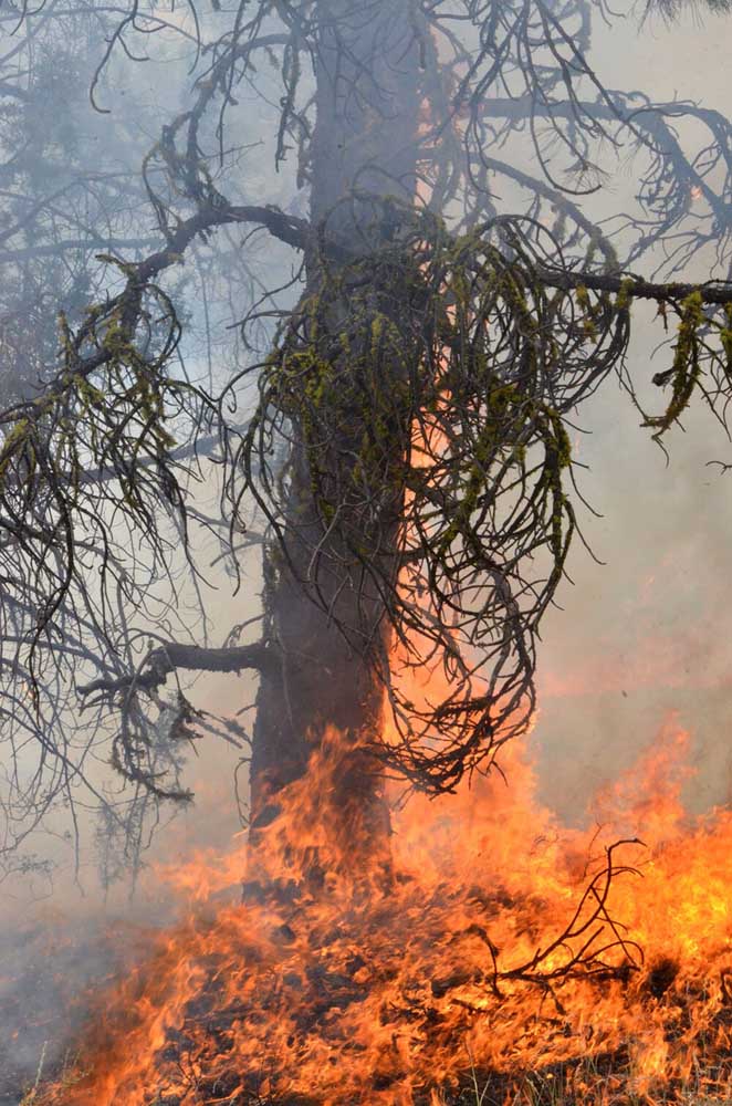
BURNS, Ore. — The Falls Fire surged again on July 17, swelling to an estimated 110,674 acres with 5% containment, fire managers say.
The fire is burning approximately 13.5 miles north of Burns, 11 miles southwest of Seneca, 7.5 miles south of Izee, and 3 miles west of Highway 395.
On July 17, there was significant fire growth in the northwest and northeast areas of the fire.
In the northwest corner, the fire crossed primary control lines and moved northerly down the Corral Creek drainage onto the ridge east of Donivan Mountain. Fire resources working in the area responded by building dozer line on the western flank of the fire and shifted engines and crews to protect values on private land.
In the northeast corner, two spot fires started in an area north of Burnt Mountain and south of Myrtle Park Meadows just east of Forest Service Road 31. Fire crews in the area responded and worked to line the fire with dozers.
Fire crews and equipment, both ground and air, continued to establish control line along the northern flank of the fire where conditions allowed for safe operations.
At the southeastern area of the fire, firefighters tied in the dozer line that now connects the 3110 and 3120 roads from the Mosquito Flats area at Lone Pine Road in the south to FSR 31 to the north near Van Zandt Meadows.
Firefighters continued to be successful at keeping the fire from coming out of the Lake Creek drainage. Control lines along much of the south and west portions of the fire, along FSR 43, continue to hold firm as mop-up operations continue.
Aerial resources, including five helicopters, six single-engine air tankers, two large air tankers, and two very large air tankers, helped to slow the fire’s growth, and supported efforts to construct flanking control lines.
On Thursday, fire behavior is predicted to be heavily influenced by very active, erratic, multidirectional winds similar to Wednesday.
In response to Wednesday’s fire growth in the northwest and northeast corners of the fire, available resources will be shifted to these areas in an effort to protect the community of Izee and homes and ranches to the north of the fire. Fire crews and heavy equipment will be constructing control lines around where the fire grew near Donivan Mountain.
In the northeast, crews and equipment will be constructing control lines around two spot fires that spotted over FSR 31 north of Burnt Mountain. Mop-up operations will continue on portions of the southern and western areas of the fire along FSR 43. Firefighters will continue to scout for future control lines.
Two Oregon State Fire Marshal task forces are assigned to the north and northeastern corner of the fire on Thursday. This includes the community of Izee, the Silvies Valley Ranch area, and the city of Seneca.
Two task forces will work along the 395 and 31 roads prepping structures. Structure protection is a priority for OSFM crews. Crews will continue triage assessment and fire protection efforts on the northern flank. One crew will continue to support wildland suppression efforts improving control line while moving forward with triaging efforts along the southern flanks of the fire in the Lodge Pine area.
Community members with questions can contact the Non-Emergency County Information Line at 541-589-5579.
Thursday’s predicted weather includes very active, erratic, and shifting wind conditions. Temperature highs will be 90–98 degrees and with very low relative humidity levels.
Evacuation notices remain in effect in Grant and Harney counties. For the most accurate evacuation information, please visit the Harney County Sheriff’s evacuation map here: https://tinyurl.com/3zst4sjy, or the Grant County Emergency Management Facebook page at: https://www.facebook.com/profile.php?id=100068819321423.
The Malheur National Forest issued a fire area closure. A detailed map and additional information about the fire area closure are available at: https://www.fs.usda.gov/detail/malheur/news-events/?cid=FSEPRD1188914.
A temporary flight restriction remains in place over the fire area.
Size: 110,674
Start Date: July 10, 2024
Location: 13.5 Miles NW of Burns, Oregon
Containment: 5%
Total Personnel: 1,559
Cause: Human-caused, under investigation
Resources Assigned: 48 hand crews, 79 engines, 17 bulldozers, and 24 water tenders
