


ONLINE Dan Fulleton Farm Equipment Retirement Auction
THIS WILL BE AN ONLINE AUCTION Visit bakerauction.com for full sale list and information Auction Soft Close: Mon., March 3rd, 2025 @ 12:00pm MT Location: 3550 Fulleton Rd. Vale, OR […]
Published 8:45 am Tuesday, August 20, 2024
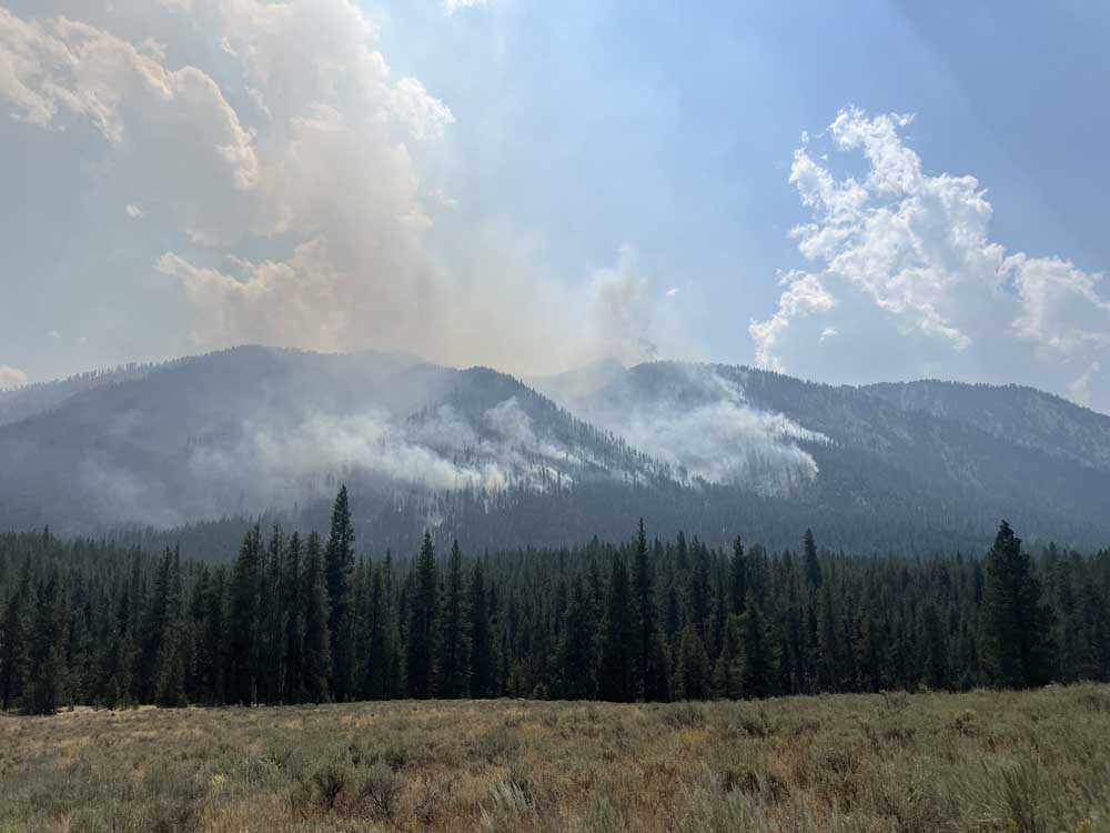
Crews battling the Middle Fork Complex, Wapiti and Bulltrout fires faced tough conditions again Aug. 19, two days after six structures were lost near Grandjean, Idaho.
Similar to Aug. 17-18, “we have hot weather, we have dry conditions and we have fuels that are receptive,” said Doug Laye, a Middle Fork Complex spokesman. “It’s going to be another day where the conditions are conducive to fire on the ground. The plan that has been put into place has accounted for that.”
The Aug. 19 plan reflects that, “today, we could get fire growth,” he said. “Terrain, and especially weather, can produce a condition you have to react to.”
Full suppression strategies are used on 62 large, active wildfires around the U.S., according to the National Interagency Fire Center’s Aug. 19 daily report. The day’s effort involved 22,235 firefighters and support personnel, five Type 1 management teams — the top level among five team types — 514 crews, 997 engines, 127 helicopters and four Modular Airborne Fire Fighting Systems. The systems drop retardant from C-130 military cargo planes.
Sixty fire-line management personnel from Australia and New Zealand are assigned to support large fires in the Northwest, and 245 U.S. Army soldiers based at Joint Base Lewis McChord, Wash., are supporting wildfire operations in the Boise National Forest.
Windy conditions from the Columbia Basin of Washington and Oregon south and east were expected Aug. 19 along with low relative humidity, according to NIFC.
The Boise-based Fire Center tracks fires of at least 100 acres in timber, 300 on grassland, and those that are in multi-fire complexes or deploy an incident management team.
From Jan. 1 to Aug. 19, U.S. burned acres increased from just over 1.75 million a year earlier to over 5.4 million. The number of fires dropped from 36,146 to 30,866.
The Middle Fork Complex, nine miles east of Garden Valley, Idaho — 5% contained as of early Aug. 19 — comprises Bulldog and Nellie Fires.
Separately, the Wapiti Fire is burning two miles southwest of Grandjean and the nearly contained Bull Trout Fire is 15 miles west-northwest of Stanley.
Middle Fork Complex fires on Aug. 19 were expected to grow to the northeast amid weather similar to that seen the previous two days, according to an InciWeb report. Crews continued to work to protect private property and structures near Crouch.
Within the complex, plans for the Nellie Fire included protecting specific points and infrastructure in the Deadwood Reservoir area and along the State Highway 21 corridor.
The Bulldog Fire Aug. 19 was expected to grow to the northeast, following north-northeast growth the previous day, according to a bulletin from Middle Fork Complex managers. The southern edge was holding, helped by continued work on protection lines from west to east.
The Wapiti Fire grew Aug. 17-18. Six structures were lost in the Wapiti Summer Home area, according to the bulletin.
As of Aug. 19 — a day after the fire showed “continued active fire behavior due to weather conditions, fuels and terrain,” the InciWeb report said — crews continued to work around the clock to secure the fire near structures and other assets. Planes and helicopters are used as smoke and visibility allow.
Wapiti crews faced elevated to near-critical dry, unstable weather Aug. 19 compared to critical conditions Aug. 18.
Boulder, nine miles southwest of Cascade within West Mountain Complex, 2,288 acres, 35% contained.
Cracker Jack Complex, 2.5 miles east of Concord, 265 acres, no containment.
Dollar, 18 miles northeast of Cascade within West Mountain Complex, 1,865 acres, no containment.
Farrow, 48 miles southeast of Elk City, 500 acres, no containment.
Flat, 11 miles north of Idaho City, 3,585 acres, 14% contained.
Goat, 11 miles southeast of Cascade in West Mountain Complex, 1,405 acres, no containment.
Limepoint, eight miles northeast of Oxbow Dam, 32,212 acres, 58% contained.
Middle Fork Complex, nine miles east of Garden Valley, 24,503 acres, 5% contained.
Snag, 9.5 miles east of Cascade within West Mountain Complex, 21,464 acres, no containment.
Wapiti, two miles southwest of Grandjean, 9,049 acres, 10% contained
Wolf Creek, five miles west of Donnelly within West Mountain Complex, 1,154 acres, 95% contained.
Wye, seven miles northeast of Moose Creek Airstrip, 5,015 acres, no containment.
Battle Mountain Complex, west and south of Ukiah, 183,026 acres, 94% contained.
Cliff Mountain, 25 miles east of Joseph, 1,108 acres, 75% contained.
Crazy Creek, 16 miles north of Paulina, 86,955 acres, 93% contained.
Diamond Complex, 18 miles southwest of Chemult, 10,984 acres, 38% contained.
Dixon, near Tiller, 1,970 acres, 47% contained.
Falls, 20 miles northwest of Burns, 151,680 acres, 95% contained.
Homestead Complex, 30 miles northeast of Glide, 5,832 acres, 31% contained.
Lane 1, 16 miles southeast of Springfield, 25,250 acres, 61% contained.
Middle Fork, Crater Lake National Park Middle Fork area, 5,222 acres, no containment.
Ore, eight miles southeast of Oakridge, 3,132 acres, 14% contained.
Red, Diamond Peak Wilderness, 16 miles west-northwest of Crescent, 730 acres, no containment.
Sandstone, nine miles southwest of Ripplebrook, 702 acres, 19% contained.
Telephone, 16 miles northeast of Burns, 54,034 acres, 95% contained.
Warner Peak, three miles east of Plush on Hart Mountain Antelope Refuge, 65,866 acres, 85% contained.
Whisky Creek, six miles southeast of Cascade Locks, 1,973 acres, 9% contained.
Willamette Complex, Oakridge area, 13.005 acres, no containment.
2620 Road, five miles west of Brinnon, 398 acres, 8% contained.
Cougar Creek, 1 mile west of Highway 129-Grand Ronde River intersection, 24.091 acres, 80% contained.
Easy, 17 air miles west of Mazama, 2,130 acres, 29% contained.
Miners, 21 air miles east of Darrington, 1,098 acres, no containment.
Pincer Two, Johannesburg Mountain one mile east of Mineral Park Campground, 189 acres, no containment.
Pioneer, 10 miles southeast of Stehekin, 38,727 acres, 23% contained.
Reinbold, near Davenport, 386 acres, 60% contained.
Retreat, 14 miles west and south of Naches, 45,601 acres, 85% contained.
Ruby, nine miles east of Newhalem in North Cascade National Park, 902 acres, no containment.
Wicked Drive, near Long Lake, 700 acres, no containment.
Williams Mine, 3.5 miles north-northwest of Trout Lake, 11,555 acres, 5% contained.
Boise, southeast of Orleans, 11,946 acres, 13% contained.
Borel, three miles southwest of Lake Isabella, 59.288 acres, 94% contained.
Coffee Pot, nine miles southeast of Three Rivers, 869 acres, no containment.
Crozier, northwest of Slate Mountain in El Dorado County, 1,938 acres, 91% contained.
Middle, near Middle Fork Tuolumne River west of White Wolf Lodge, Yosemite NP, 310 acres, 85% contained.
Park, Upper Bidwel Park, Butte, Tahama and Shasta counties, 429,388 acres, 53% contained.
Trout, Tulare County, 24,781 acres, 5% contained. (Source: Cal Fire)
