


ONLINE Dan Fulleton Farm Equipment Retirement Auction
THIS WILL BE AN ONLINE AUCTION Visit bakerauction.com for full sale list and information Auction Soft Close: Mon., March 3rd, 2025 @ 12:00pm MT Location: 3550 Fulleton Rd. Vale, OR […]
Published 3:15 pm Monday, August 5, 2024
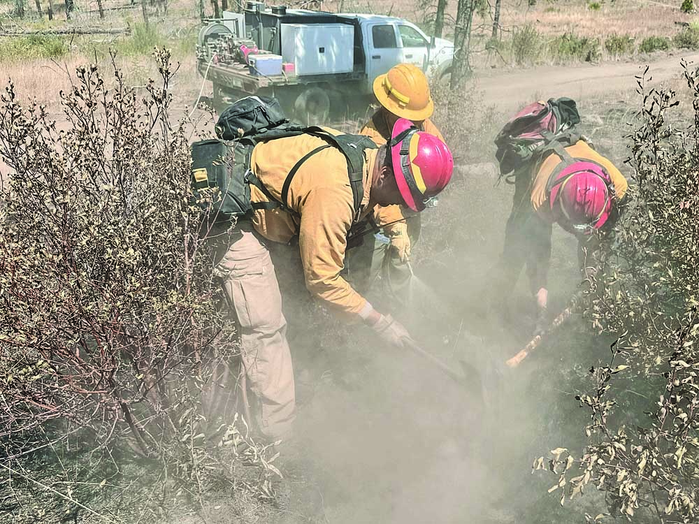
Durkee Fire crews worked Aug. 5 to increase their containment of the massive wildfire beyond 86%, maintain protection lines and set the stage for equipment redeployment and post-fire landscape recovery.
Meanwhile, firefighters working on the 294,690-acre fire west of Durkee, Ore., will “have their heads on a swivel and their eyes to the sky,” said Ray Butler, an incident public information officer.
U.S. wildfire acres burned from Jan. 1 to Aug. 5 approached 4.7 million, up more than threefold from nearly 1.3 million in the year-earlier period, according to the National Interagency Fire Center. The number of fires is lower — 29,132 compared to 31,718. The center tracks large fires such as those that burn at least 100 acres of timber or 300 acres of rangeland or are managed as multi-fire complexes.
East of Chico, Calif., the 401,740-acre Park Fire was 34% contained early Aug. 5. Spread was limited to the eastern portion overnight, with continued burning of larger dead and down fuels, according to a California Department of Forestry & Fire Protection situation summary.
The portion of the fire burning in Mill Creek remained active overnight with hot and dry conditions and increased wind contributing to more fire activity.
Critically low fuel moisture, steep canyons and long drive times have caused increased fire activity, according to the Cal Fire summary. For Aug. 5, Park Fire managers expected increased smoke — especially over the northeast section where the fire is active.
Firefighters are working to connect a mix of roads, dozer lines and fire-protection lines from Highway 36 to Tamarack Road and parallel to the Mill Creek drainage on the north side, according to an Aug. 5 update from the Lassen National Forest, where the Park Fire had burned 95,743 acres. On the southern rim, crews are using heavy equipment to improve Forest Service roads to prevent fire advancement south and east. Firefighters will plumb hose into protection lines on both sides of the rim.
Park Fire managers and crews for Aug. 5 expected high temperatures in the low 100s, a drop in minimum relative humidity to the lower to mid-teens and afternoon wind gusts to nearly 20 miles per hour, according to the Cal Fire summary. A Cal Fire incident spokesperson could not be reached.
A dry southwesterly flow was expected to continue across the Inland Northwest into Northern California and the western Great Basin amid above-normal temperatures, according to the Fire Center’s daily report Aug. 5, when nearly 30,000 firefighters and support personnel were assigned to wildfires. Winds and lower humidities likely will create “locally elevated conditions” strongest through the Cascade gaps, in Northern California and along the Sierra front.
Durkee Fire crews, in addition to securing remaining protection lines to get to full containment, are repairing existing lines initially dug down to bare mineral soil. Butler said. The repaired lines “will not be perfect, but will be ready for the rehab team.”
Equipment back-haul, by which excess equipment is cleaned, repaired and readied for deployment elsewhere, “has been kind of a trickle-in process but is really stepped up now,” he said. Equipment and operating crews do “what work is left on the line and bring it back in,” often to a staging area.
Durkee Fire managers prepared for possible afternoon thunderstorms Aug. 5 and the start of a prolonged period of above-average temperatures and dry conditions, “increasing fire danger,” according to an update.
“Nature will take its course,” Butler said.
Baker County evacuation levels related to the Durkee Fire have not changed since July 30, according to an Aug. 2 Facebook post by the sheriff’s office. The Malheur County Sheriff’s Office in a July 25 post said it had lifted all evacuation recommendations.
Selected wildfires Aug. 5 (Source: NIFC)
California
Borel: 12 miles southwest of Lake Isabella, 59,340 acres, 57% contained.
Hill: eight miles south of Willow Creek, 7,224 acres, 91% contained.
Long: 15 miles northeast of Kernville, 9,204 acres, 95% contained.
Nixon: 20 miles east of Temecula, 5,222 acres, 82% contained.
Park: east of Chico, 402,042 acres, 34% contained (Cal Fire).
Pedro: 10 miles northeast of La Grange, 3,815 acres, 70% contained.
Pole: six miles south of Apple Valley, 300 acres, 96% contained.
Sentinel: 50 miles east of Sanger, 165 acres, 40% contained.
Shelly: Marble Mountain Wilderness-Klamath National Forest, 15,520 acres, 92% contained.
Trout: 18 miles north of Kernville, 23,559 acres, 49% contained.
Idaho
Bench Lake: Eight miles south of Stanley, 2,595 acres, 90% contained.
Bluff Creek Complex: 13.5 miles southeast of Avery, 432 acres, 20% contained.
Boulder: Nine miles southwest of Cascade, 841 acres, 5% contained.
Bulltrout: 15 miles west-northwest of Stanley, 271 acres, 41% contained.
Gardner: Nine miles northwest of Carey, 1,143 acres, 70% contained.
Gwen: South of Juliaetta, 28,820 acres, 90% contained.
Limepoint: Eight miles northeast of Oxbow Dam on the Middle Snake River, 24,605 acres, 5% contained.
Thunder: 12 miles south-southwest of Salmon, 2,474 acres, 50% contained.
Wolf Creek: Five miles west of Donnelly, 1,123 acres, 6% contained.
Wye: Seven miles northeast of Moose Creek Airstrip, 3,466 acres, no containment.
Oregon
Adam Mountain: Six miles south of Dorena, 11,998 acres, 9% contained.
Badland Complex: Baker County, 54,563 acres, 99% contained.
Battle Mountain Complex: West and south of Ukiah, 181,941 acres, 36% contained.
Cliff Mountain: 25 miles east of Joseph, 1,108 acres, 20% contained.
Courtrock: 7.1 miles south of Monument, 20,018 acres, 57% contained.
Crazy Creek: 16 miles north of Paulina, 64,288 acres, 6% contained.
Diamond Complex, 18 miles southwest of Chemult, 6,134 acres, 11% contained.
Double Snag: 15 miles east of Dale, 131 acres, 75% contained.
Durkee: 1 mile west of Durkee, 294,690 acres, 86% contained.
Falls: 20 miles northwest of Burns, 146,113 acres, 73% contained.
Homestead Complex: 30 miles northeast of Glide, 2,532 acres, 9% contained.
Lane 1: 16 miles southeast of Springfield, 2,395 acres, 9% contained.
Lone Rock: Lone Rock west to Highway 207 and south to Highway 19, 137,222 acres, 92% contained.
Microwave Tower: Five miles west-southwest of Mosier, 1,311 acres, 59% contained.
Middle Fork: West of Crater Lake, 1,938 acres, 1% contained.
Oakridge Lightning and Willamette Complex: Willamette National Forest, 10,450 acres, containment not listed (NIFC and InciWeb).
Ore: seven miles northeast of Blue River, 1,766 acres, 29% contained.
Poison Creek: 10 miles southeast of Seneca, 1,047 acres, 50% contained.
Red: Diamond Peak Wilderness, 490 acres, no containment.
Sand: 26 miles northwest of Burns, 5,958 acres, no containment.
Telephone: 16 miles northeast of Burns, 52,130 acres, no containment.
Whiskey Mountain: 10 miles south of Izee, 4,345 acres, 63% contained.
Whisky Creek: six miles southeast of Cascade Locks, 1,174 acres, no containment.
Wickiup: Eight miles west of La Pine, 168 acres, 90% contained.
Winding Waters Complex: Wallowa County, 752 acres, 83% contained.
Washington
Cougar Creek: One mile west of Highway 120 and Grand Ronde River intersection, 20,666 acres, 35% contained.
Easy: North Cascades Highway 20 Corridor 17 air miles west of Mazama, 1,056 acres, no containment.
Miners: 21 air miles east of Darrington, 500 acres, no containment.
Pincer Two: Johanasburg Mountain one mile east of Mineral Park Campground, 102 acres, no containment.
Pioneer: 10 miles southeast of Stehekin, 35,607 acres, 12% contained.
Retreat: 14 miles southwest of Naches, 41,279 acres, 49% contained.
Swawilla: 10 miles southwest of Keller, 53,403 acres, 90% contained.
