


ONLINE Dan Fulleton Farm Equipment Retirement Auction
THIS WILL BE AN ONLINE AUCTION Visit bakerauction.com for full sale list and information Auction Soft Close: Mon., March 3rd, 2025 @ 12:00pm MT Location: 3550 Fulleton Rd. Vale, OR […]
Published 10:00 am Wednesday, September 11, 2024
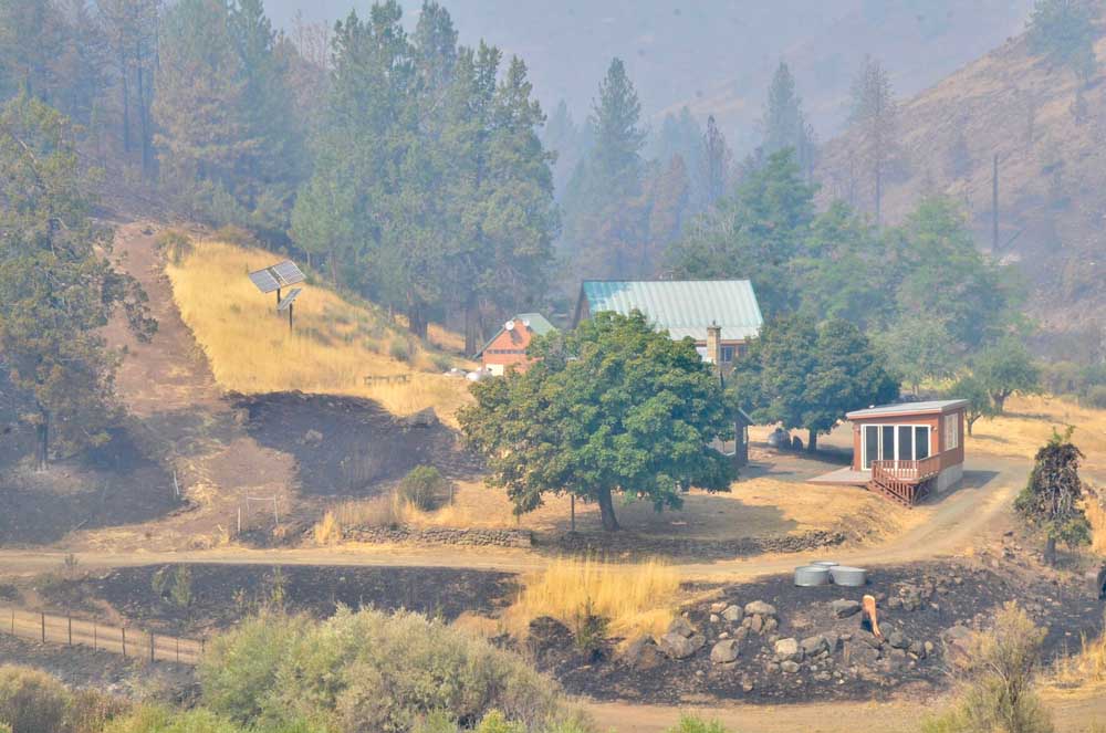
DAYVILLE, Ore. — The Rail Ridge Fire has grown to over 150,000 acres as containment ticked up to 11%.
Infrared imaging taken from the air shows the fire has grown to 157,759 acres and is burning 1.5 miles south of Dayville in the South Fork John Day River drainage, fire managers said in an update.
Of the five blazes of 100,000 acres or more currently burning in Oregon, three are partly in Grant County. In addition to the Rail Ridge Fire, they are the Falls Fire (152,000 acres) and the Battle Mountain Complex (183,000 acres).
The 294,000-acre Durkee Fire and the 137,000-acre Lone Rock Fire are in neighboring counties.
California Complex Interagency Incident Management Team 10 took command of the fire at 7 a.m. on Sept. 6. The number of firefighters on site to battle the blaze continues to rise and is now sitting at 975 compared to yesterday’s count of 739.
Fire behavior was moderate through the morning and early afternoon yesterday, allowing opportunities for firefighters to reevaluate and improve upon preparation work completed earlier this week.
Favorable winds gave crews a hand overnight with fire approaching Dayville. The fire continued to move slowly toward town with no high-intensity fire observed and no containment issues noted.
Mapping Tuesday morning shows the fire about 1.5 miles from town moving gently into containment lines. In the late afternoon, fire activity increased and became visible along ridgetops behind Dayville. Continuing to catch that fire as it moves to the northeast remains the priority for today.
Yesterday, task forces from Oregon State Fire Marshal (OSFM) were strategically positioned at structures in the Dayville, Fields Creek, and Suplee areas. Crews also completed damage assessments on structures that were impacted by fire earlier in the week. The number of destroyed structures did not change.
OSFM crews will continue to assess and reinforce structural protection measures at structures near the fire line, including in Dayville, Suplee, Fields Creek, Battle Creek, and the Morgan Mountain area. Multiple task forces are in place, committed to structural protection around the clock.
Crews are aggressively working in the South Fork, in Division Golf and Division Juliet. Erratic gusty winds have been noted for several days in the South Fork of the John Day River, and spotting continues to occur. Due to the steep, inaccessible terrain, crews have had a difficult time getting to the spots to contain them, and they are looking at opportunities to stop fire progression towards the Morgan Ranch area.
To the south along the Paulina/Supplee Road, the fire continues to back into containment lines with no issues. The western edge of the fire has also been quiet for the last several days, and firefighters have seen very little movement.
Cooler, wetter weather is anticipated to move into the fire area today, and crews are poised to take advantage of these conditions to continue to build containment. A return to drier weather is anticipated for Friday, although temperatures should remain cool.
Both the Ochoco National Forest and BLM have implemented partial closures due to the fire. For more details and closure maps, visit the Ochoco National Forest, Malheur National Forest, and BLM webpages.
For the most up-to-date evacuation information, please visit:
• Crook County: Crook County Emergency Management website and Crook County Sheriff’s Office Facebook page.
• Wheeler County: Wheeler County Sheriff’s Office Facebook page.
• Grant County: Grant County Emergency Management Facebook page.
An evacuation shelter has been set up at the Mt. Vernon Community Hall, located at 640 S. Ingle Street in Mt. Vernon. Large animals can be housed at the Grant County Fairgrounds, located at 411 NW Bridge St in John Day.
