


ONLINE Dan Fulleton Farm Equipment Retirement Auction
THIS WILL BE AN ONLINE AUCTION Visit bakerauction.com for full sale list and information Auction Soft Close: Mon., March 3rd, 2025 @ 12:00pm MT Location: 3550 Fulleton Rd. Vale, OR […]
Published 9:45 am Thursday, December 5, 2024
The biggest changes in flood-risk management under the modernized Columbia River Treaty will be felt during moderately wet years, about 30% of the time, federal officials say.
Operations will look similar in dry to average or the wettest years, said Steve Barton, Columbia Basin Water Management Division chief for the U.S. Army Corps of Engineers, during a public information session Dec. 4 hosted by the Corps and the U.S. Bureau of Reclamation.
The U.S. and Canada announced in July an agreement in principle on key aspects of a modernized treaty, a process that could still take up to two years.
Operations for preplanned flood-risk management space in Canada ended Sept. 16.
The Canadian portion of the treaty is responsible for managing a large share of the floodwaters due to heavy snow that accumulates in the northern Rocky Mountains.
The U.S. can continue to access storage space in Canada for flood-risk management, but access looks different from the first 60 years of the treaty.
Once the agreement enters into force, it provides for 3.6 million acre-feet of flood-risk management capacity in Arrow Lake in Canada.
Until then, the U.S. and Canada will be in an interim period, prompting the need for a new operating plan for flood-risk management.
The Corps worked with Canada to secure the 3.6 million acre-feet of capacity for 2025, with the option to pay for two additional years if Congress appropriates the funding, said Brigadier Gen. Bill Hannan, Northwestern Division commander of the Corps.
The 3.6 million-acre feet of preplanned storage capacity is less than the U.S. has had in the past, Barton said.
U.S. reservoirs may need to make up for some of the lost storage in some years to prevent flooding.
Moderately wet years, about 30% of all years, are the years expected to show the most significant differences in operations.
Operations are very similar the rest of the year, as Lake Roosevelt refills by early July, he said.
In dry to average years, about 60% of all years, operations would be similar to years under the original treaty.
In the wettest years, about 10% of all years, the “band of unpredictability is very small” because Lake Roosevelt is required to be at low levels regardless of Canadian operations.
“Lake Roosevelt must be at low levels when snowpacks are high to manage spring runoff,” Barton said.
Without an agreement, Lake Roosevelt would be drafted deeper during winter and spring runoff.
“With the agreement in principle, this worst-case scenario is no longer our reality,” Barton said.
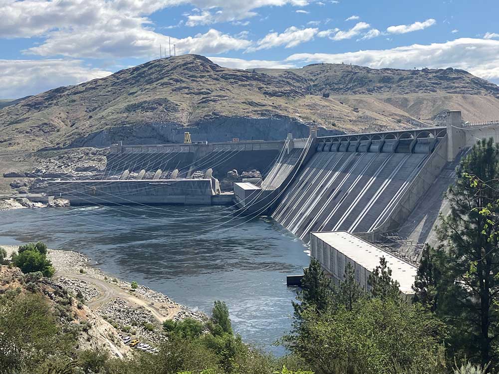
John Day Dam, near Rufus, Ore., is not frequently used for flood-risk management but is authorized for it.
Before the Sept. 16 expiration, it was needed about 10% of the time. With the change, it may be needed 20%, Barton said.
Peak river levels in the Portland and Vancouver, Wash., areas would be about the same, but flows may stay higher for longer, about a week or so more, he said.
Without upstream reservoirs, water levels would have risen 10 feet above the flood stage, “which would have caused extensive damage,” he said.
Higher costs may be incurred if more tugboats are needed to push against strong currents due to higher flows on the Columbia River, Barton said.
High-water events may be a few days longer in wetter water years.
When the John Day Dam pool is lower, it may also increase river currents and require more energy to move goods upstream. Costs may increase from John Day at lower elevations for a few weeks between April and June.
“We do not currently believe navigation up and down the river will be interrupted as a result of real-time flood risk management,” Barton said.
Low flows could result in restrictions on barge drafts, but the changes are not expected to impact the frequency of low flows, he said.
Irrigation withdrawals from the John Day pool, Lake Umatilla, typically last from March to mid-November. Before September 2024, the lake rarely dipped below minimum irrigation pool elevations during the irrigation season.
Under the changes, John Day may be drafted below those levels more often, up to 5 feet lower, causing seasonal impacts on irrigation pumps, typically for a few weeks between April and June, said Eric Rothwell, Columbia River hydrology coordinator for Reclamation.
If Grand Coulee Dam provides more capacity under real-time flood risk management in moderately wet years, pumping irrigation water from Lake Roosevelt to Banks Lake could be reduced at times, Rothwell said.
“It’s possible there would be less pumping in April through May, and more in June through August,” he said.
The cost to pump the water to Banks Lake would increase from 1% to 4% in some of those years, he said.
Pumping changes could mean a need to draw down stored water in Banks Lake to meet seasonal irrigation demands.
“Banks Lake water levels may fluctuate more than historically, but we do not foresee any impacts to our ability to deliver water as needed to the Columbia Basin Project,” he said.
The preplanned flood-risk management could affect the cost and schedule of phase two of a plan to reintroduce salmon into the upper Columbia area, but impacts should be limited, Rothwell said.
Changes in flows in some years could affect anadromous and resident fish, he said.
Relying on real-time flood risk management could result in longer, deeper drawdowns at Lake Roosevelt and Lake Umatilla.
In moderately wet years, the longer, deeper drawdowns could expose cultural and archaeological sites more often than under previous operations, making them more vulnerable to shoreline erosion, mass wasting and looting, Rothwell said. The agencies will continue to work with Tribes to protect the resources.
