


ONLINE Dan Fulleton Farm Equipment Retirement Auction
THIS WILL BE AN ONLINE AUCTION Visit bakerauction.com for full sale list and information Auction Soft Close: Mon., March 3rd, 2025 @ 12:00pm MT Location: 3550 Fulleton Rd. Vale, OR […]
Published 8:15 am Monday, May 13, 2024
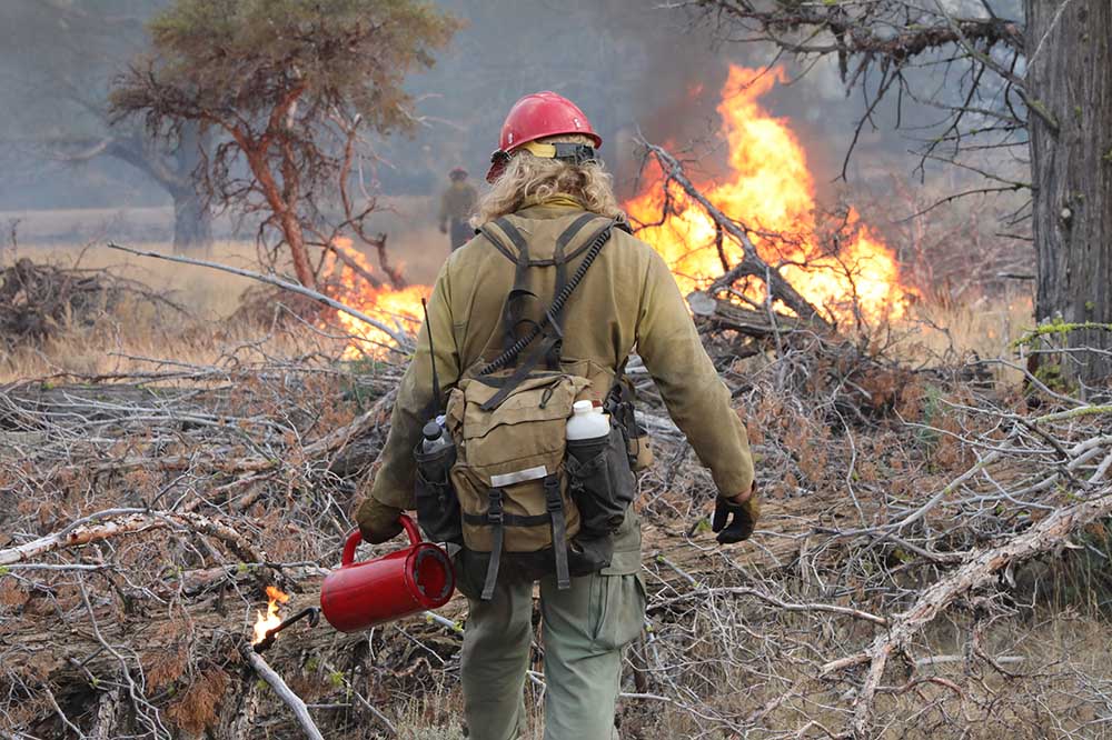
Boise National Forest fire managers plan six prescribed fires totaling 1,354 acres starting this week.
The prescribed fires are part of the U.S. Forest Service’s Wildfire Crisis Strategy, which aims to reduce the risk of future catastrophic wildfires to nearby communities and natural resources, according to a Boise National Forest news release. The forest lies north and east of Boise.
Managers and crews conduct prescribed fires in wind conditions that favor dispersing smoke out of populated areas, but smoke may be seen for several days after a burn, according to forest officials.
Here are the locations:
• Boise Basin Experimental Forest: 187 acres a mile north of Idaho City along Forest Road 307. To start May 13 and include one to two days of burning, five to seven days of post-fire monitoring. Smoke may impact Idaho City and State Highway 21.
• Avelene: 250 acres eight miles southwest of Idaho City, near intersection of Grimes Creek and Clear Creek. Previously scheduled May 1 but delayed due to weather, according to the release. To start May 13 and include one to two days of burning and five to seven days of post-fire monitoring.
• Mores South: 145 acres four miles east of Idaho City along Forest Service Road 327, also known as Rabbit Creek Road. A fire was started April 30 but was not completed due to weather. A restart is set May 14. Plans call for one to two days of burning and five to seven days of post-fire monitoring. Smoke may impact Idaho City, Highway 21 and the Granite Creek Recreation Site.
• Crawford: 86 acres at Crawford Work Center, three miles east of Cascade along Warm Lake Road. To start May 13 and include two to three days of burning, five to seven days of post-fire monitoring. Smoke may impact Cascade and the State Highway 55 corridor.
• West Lowman: 613 acres combined in three burn areas between 1.5 and 4.5 miles east of Lowman along Highway 21. Planned May 14-17 including three to four days of burning and five to seven days of post-fire monitoring. Smoke may impact the highway area in and around Lowman.
• High Fork: 73 acres about 7.5 miles north of Ola, north of High Valley. To start May 15 and include one day of burning, five to seven days of post-fire monitoring. Smoke may impact the Highway 55 corridor, Smiths Ferry and Ola, according to forest officials.

THIS WILL BE AN ONLINE AUCTION Visit bakerauction.com for full sale list and information Auction Soft Close: Mon., March 3rd, 2025 @ 12:00pm MT Location: 3550 Fulleton Rd. Vale, OR […]
Featuring quality surplus farm and dairy equipment from farming operations and dealers across Western, WA. Highlights include sellers from Lynden to Snohomish featuring equipment from Farmers Equipment, Inc., Cleave Farms, […]
Bid Now! Bidding Ends March 12, 10 AM MST Dairy, farm, excavation & heavy equipment, transportation, tools, & more! Register Now! Magic Valley Auction www.MVAidaho.com 208-536-5000
Treasure Valley Livestock Auction Caldwell, Idaho Free Delivery within 400 Miles February 25th, 2025 @ 1PM MST VIEW/BID LIVE ON THE INTERNET: LiveAuctions.TV Find us on Facebook at: Idaho […]
The in-person and virtual conference will feature more than 90 speakers, as well as presentations, panel discussions and networking. Organic Seed Alliance (OSA), along with partner Oregon State University’s Center […]
Live Streaming Auction - February 26, 2025 Timed Auction (Online Only!) - February 27, 2025 View Catalogs: Day 1 | Day 2
Range-Raised • Feedlot-Tested • Carcass-Measured • DNA Evaluated Price Cattle Company with Murdock Cattle Co February 26 Lunch Served At 11:00 AM • Sale Starts 1:00 PM 50 Registered Angus […]
The event features research updates and educational presentations.
Live Streaming Auction - February 26, 2025 Timed Auction (Online Only!) - February 27, 2025 View Catalogs: Day 1 | Day 2
Moving Back Home! In addition to our yearling bulls, we also added some age-advantage bulls. The sale will take place at the Lewiston Roundup Grounds, just South of Lewiston. Both […]
FRIDAY – February 28, 2025 / 8:30 AM 17129 HIGHWAY 99 NE, WOODBURN, OR 97071 AUCTION DETAILS: Auction Begins: Friday – February 28th, 2025 @ 8:30 AM – (PST) Live-online […]
Trinity Farms BETTER BULLS. BRIGHTER FUTURES. Trinity composite bulls, the perfect solution for advanced beef production. 250 Bulls Available Ellensburg, WA • 3.1.2025 www.trinityfarms.info • (509) 201-0775
Preview: Sat. March 1st 9am - 1 pm Biddings Ends: Thurs. March 6th Starting at 6pm Highlights Include: Bulb planter and harvest equipment, disks, plows, harrows, cultipackers, 4 row planter, […]
Heavy Equipment • Tractors • Construction • Farm Equipment • Vehicles • Trucks • Trailers & More! Virtual Online-Only Auction Full Catalog & Bidding Procedures Available at www.yarbro.com Start […]
Booker's Annual Early Spring Eltopia Auction March 6-7, 2025 www.BookerAuction.com | 509.297.9292
2-Day Online Equipment Auction @ Meridian Equipment Auction CO, Bellingham WA. Now Accepting Quality Machinery Consignments AUCTION INFORMATION Online Only Bidding ONLINE BIDDING OPENS: Feb 22, 2025 DAY 1- Online […]
Oregon State University Surplus hosts Annual Farm Sale Bid on 30+ years of local farm surplus! Join OSU Surplus on March 8th at the Lewis Brown Farm in Corvallis for the […]
Join us for the Genetic Edge Bull Sale! 320 Coming Two-Year-Old Bulls • 265 Yearling Bulls • 305 Calving-Ease Bulls Schedule of Events Friday, March 7, 2025 All Day […]
March Online Equipment Consignment Auction Online Bidding is Wed, March 12th - Wed, March 19th Chehalis Livestock Market 328 Hamilton Rd. N., Chehalis, WA 98532 Follow Us on Facebook! @Chehalis […]
Online Auction - March 12th Bid Now! Dairy, Farm, Excavation & Heavy Equipment, Transportation, Tools, & More! Magic Valley Auction MVAidaho.com 208-536-5000
Bidding starts on Wednesday, March 12th Go to www.clmauctions.com and click on Hibid link to view and bid on over 1,000 lots! Lots of great pickups, trailers, tractors, cars, farm trucks, haying […]
ONLINE ONLY AUCTION Schritter Farms Retirement Auction Bidding Now Open! Bids Begin Closing on March 12th @ 9AM MST Multiple Locations - Please See Individual Lots For Their Specific Location, […]
Thursday, March 13th at 9:30 AM ~ Bill Miller Rentals ~ Rubbered Tired Loaders, Crawler Tractors, Cranes, Motor Graders, Haul Trucks, Excavators, Water Trucks, Truck Tractors, Trailers, Attachments and Support […]
RAM RIDGE LLC & PALM CONSTRUCTION - ONLINE AUCTION Aggregate Crushing & Heavy Equipment Start Date: 10AM | Thursday - March 13 End Date: 10AM | Thursday - March 20 […]
Thursday, March 13th at 9:30 AM Rubber Tired Loaders, Crawler Tractors, Cranes, Motor Graders, Haul Trucks, Excavators, Water Trucks, Truck Tractors, Trailers, Attachments and Support Equipment Carlin (Elko), Nevada HIGHLIGHTS: […]
March 14th - March 18th 2025 Changes Farm Operations Maxwell, CA Learn more at AUCTION-IS-ACTION.COM Putnam Auctioneers, Inc. CA Bond No. 7238559 Email: putman.kevin@yahoo.com John Putnam - (530) 710-8596 Kevin […]
Saturday, March 15th 9:30 AM Address: 1800 West Bonanza Rd., Las Vegas, NV 89106 Highlights: 2-Tele. Forklifts: Unused JLG 943, Unused JLG 742, 2-Cab & Chassis: (2)Unused Chevy 5500, 3-Detachable […]
March Online Auction Begins to close @3pm MST | March 17, 2025 Early Listings: *2017 Bobcat 418-A-A Mini Excavator, *International 544 Utility Tractor with Loader, *2016 Bobcat E20 Mini Excavator, […]
Multi-Seller - Open Consignment Bidding Now Open - Additional Items Arriving Daily Starts Closing: Tuesday, March 18th @ 2PM (MT) Tractors • Trucks • Trailers • Construction Equipment • Farm […]
Machinery Auction March 19 & 20 All lots start to close at 8:00 a.m. PST Online Bidding Opens March 14 at 3:00 p.m. PST Items include: Construction Equipment, […]
12:30PM Wednesday, March 19, 2025 Performance Tested Bulls: Angus, Simmental and SimAngus, Red Angus, Charolais 90 Day Breeding Guarantee. Western Breeders Assoc. Bonina Feed and Sale Facility, 430 Ferguson Lane, […]
Booker's Annual Early Spring Offsite Farm Auction Ends March 19, 2025 www.BookerAuction.com | 509.297.9292
MAJOR CONSIGNORS: Twin Falls Highway District; KWS Seeds; Molyneux Family Farms; and Sev'rl Area Farmers throughout the Magic Valley NOTICE: Items listing in this auction are located at multiple locations […]
Saturday, March 22, 2025 1:00pm PT • At the Ranch • Sandpoint, ID High maternal easy fleshing Cows Low maintenance Heifers High performance Bulls Selling 47 Bulls and 40 […]
Discover the Estate of Afton Jacobson, offering 743± acres of farmland just 4 miles south of Pullman, WA. This expansive property features 6 parcels, two including residences and outbuildings, providing […]
FRIDAY – April 25, 2025 / 8:30 AM 17129 HIGHWAY 99 NE, WOODBURN, OR 97071 *Catalog coming soon* AUCTION DETAILS: Auction Begins: Friday – April 25th, 2025 @ 8:30 AM […]
Live Streaming Auction - March 26, 2025 Timed Auction (Online Only!) - March 27th, 2025 View Catalogs: Day 1 | Day 2
March 28th, 9:00 am - 5:00 pm March 29th, 9:00 am - 3 pm The 4th Annual Central Oregon Agricultural Show presents the best of the region’s agricultural industry. The […]
FRIDAY – March 28, 2025 / 8:30 AM 17129 HIGHWAY 99 NE, WOODBURN, OR 97071 AUCTION DETAILS: Auction Begins: Friday – March 28th, 2025 @ 8:30 AM – (PST) Live-online […]
ONLINE ONLY AUCTION Rowell Bros. Berry Farm Liquidation Preview: Sunday, March 30th 9AM to 2PM 24000 SW SCHOLLS FERRY RD. HILLSBORO, OR. Online Bidding Ends Thursday evening, April 3 starting […]
Bids Open at 3pm PST on March 20th Start Closing at 8am PST, April 2 & 3, 2025 On-Site Preview available Monday to Saturday from 9am to 4pm Visit www.I-5auctions.com […]
Thursday, April 3, 2025 - Brigham City, Utah Live & Online Bidding (16) Tractors - Wheel loaders - Skid Steers - (8) Semis, Trucks w/Laird Feed Box, Ross Beds - […]
THIS WILL BE AN ONLINE AUCTION Go to bakerauction.com for more information. Auction Soft Closes: Thurs., April 3rd 2025 @ 12:00pm MT Consignment Item Receiving: March 17th - March 31st, […]