


ONLINE Dan Fulleton Farm Equipment Retirement Auction
THIS WILL BE AN ONLINE AUCTION Visit bakerauction.com for full sale list and information Auction Soft Close: Mon., March 3rd, 2025 @ 12:00pm MT Location: 3550 Fulleton Rd. Vale, OR […]
Published 9:00 am Friday, November 22, 2024
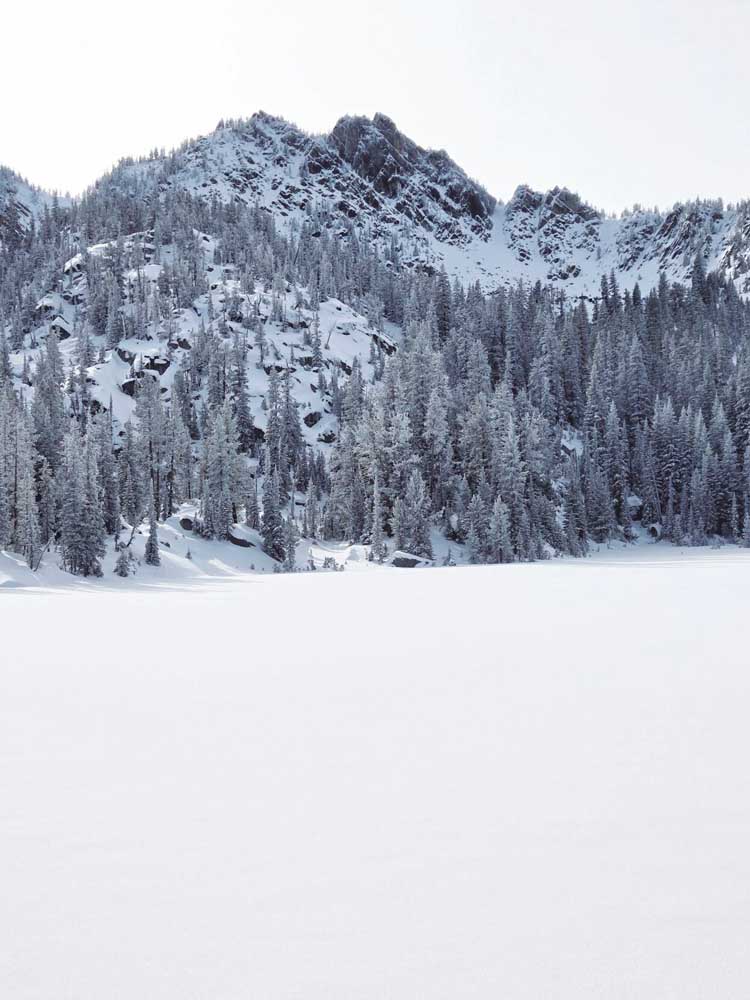
A potential solution to Northeastern Oregon’s drought woes is starting to stack up in the mountains.
The high-elevation snowpack, a vital source of water for summer irrigation as well as recreation, has been accumulating at a record pace across the region.
A storm this weekend, the latest in a series of soggy systems, piled prodigious amounts of snow throughout the Blue Mountains.
The National Weather Service is predicting the onslaught to continue into Thanksgiving week, although warmer air could push snow levels at times to the higher peaks, well above highway passes.
“It’s a great start,” said Mark Bennett, who owns a cattle ranch near Unity in southern Baker County.
According to the U.S. Drought Monitor, all of Baker, Union, Wallowa and Grant counties are in moderate drought (the least severe of the four-category index, which escalates to severe, extreme and exceptional drought).
Most of Umatilla County is also rated as being in moderate drought, the exception being the northwest corner, which is abnormally dry, the category below moderate drought. In Morrow County the southern half is in moderate drought, the northern half unusually dry.
Although the mountain snowpack typically peaks in March or early April, Bennett said he’s encouraged by the early accumulation.
The occasional rain that started falling in mid-October was also beneficial, said Bennett, a former Baker County commissioner.
Precipitation that falls before the ground freezes can soak into the soil, helping to replenish ground depleted of moisture during the hot, dry summer, Bennett said.
He said he talked with a rancher in northern Malheur County who was digging fence post holes in early October. At a depth of four inches or so, the soil was dusty, Bennett said.
The recent storms should moisten that soil, he said, so when the snowpack melts next spring more water will flow into streams and reservoirs rather than soaking into the ground.
As of Monday morning, Nov. 18, the water content in the snow, measured at more than a dozen automated stations in Northeastern Oregon and Southeastern Washington, was about three and a half times above average.
The stations, called “Snotels,” (a combination of “snow” and “telemetry,” as the stations send their data by radio signals) weigh the snow and calculate the water content. That’s a more meaningful statistic than snow depth, because a foot of light, powdery snow can contain less water than heavy, wet snow half as deep.
On Monday the water content at most stations was the highest on record for the date.
The majority of Snotels were installed in the late 1970s or early 1980s.
Here’s a couple examples of the unprecedented early-season snowpack:
• At Schneider Meadows, in the southern Wallowa Mountains in eastern Baker County, the water content on Monday morning was 7.8 inches. That’s the most ever measured on Nov. 18 at the Snotel, which dates to 1980. The average for the date is 1.5 inches.
The snow depth on Monday was 40 inches.
• At Blue Mountain Spring, in Grant County southeast of the Strawberry Mountains, the water content Monday morning was 4.8 inches, a record for the date. The Snotel was placed in 1978. The average for Nov. 18 is 0.6 of an inch.
The snow depth on Monday was 23 inches.
• At Tipton, along Highway 7 between Sumpter and Austin Junction, the water content Monday morning was 3.9 inches, a record for the date. The average for Nov. 18 is 0.4 of an inch. The Snotel was installed in 1980.
The snow depth Monday was 18 inches.
• At Eilertson Meadow, in the Elkhorn Mountains northwest of Baker City, the water content Monday morning was 3.1 inches, the most for the date since the Snotel was built in 1980. The average for the date is 0.4 of an inch.
The snow depth on Monday was 14 inches.
• At Taylor Green, in the western Wallowas southeast of Union, the water content Monday was 4.8 inches, a record for Nov. 18, when the average is 0.9 inches. The Snotel was installed in 1979.
The snow depth Monday was 20 inches.
• At High Ridge, in the northern Blues near Tollgate, the water content Monday was 5.2 inches. That’s the third-highest at the Snotel since it was placed in 1978, trailing 1984 (6.6 inches) and 1994 (6.2 inches). The average for Nov. 18 is 1.2 inches.
The snow depth on Monday was 21 inches.
The weekend storm doubled the water content at High Ridge and dumped nine inches of snow.
A station near Anthony Lake Mountain Resort, which measures snow depth but not water content, recorded nine inches of new snow during the weekend for a depth of 21 inches on Monday morning.
Although farmers and ranchers won’t know until next spring whether the bountiful early snow yields major benefits for the irrigation season, snowmobile riders are already celebrating the autumn storms.
“It’s definitely an early gift from Mother Nature,” said Brandon Christensen, a member of the Tollgate Trail Finders snowmobile club.
Christensen said the early snow is especially welcome after several recent years when snowmobilers couldn’t make their first tracks until some time in December.
“It’s nice to say you can get some snowmobiling in in November,” Christensen said.
The Trail Finders has two groomers that smooth dozens of miles of snowmobile trails in the northern Blues. Christensen said the club can’t start grooming until Dec. 1, though, as snowmobiles have to share trails and roads with wheeled vehicles until then.
Both of the club’s groomers are ready, he said.
